OLLI Course: Disaster Preparedness
OLLI Course: Disaster Preparedness
Course: Description | Instructor | Topics | References | Updates
Description: Disaster Preparedness: The Really Big One
- upcoming: ?
- previous: Zoom: Winter 2022; Spring 2021; Winter 2021
- Course URL:
https://communicrossings.com/disaster-preparedness
or: https://communicrossings.com/olli-course-disaster-preparedness
this site will continue to be available and updated - Disaster Preparedness: 6 MB, 123 pp,
these web pages as .pdf (landscape) with active links; updated: 1/1/2022  Zoom: Use, Setup, Safety;
recordings of sessions available to registered students
-- contact instructor.- Also see Topics (below) for detailed ToC and general references.
 If you have already lessened your property's fire vulnerability
and have planned for how to evacuate yourself and loved ones, congratulations!- What about other disasters? Students will learn about how to prepare for earthquakes,
wildfires and other risks in the Rogue Valley. - The instructor will discuss alert systems, family disaster plans,
emergency kits, go-bags and “2 Weeks Ready” supplies,
evacuation during a fire versus sheltering-in-place after an earthquake.
He will also address community programs, training and online resources. - Recommended reading: "The Really Big One" by Kathryn Schulz, New Yorker, 7/13/2015;
subtitle: "A [Cascadia] earthquake will destroy a sizable portion of the coastal Northwest. The question is when."
 Instructor
Topics
- An earlier version of this course was offered in Winter & Spring 2021.
It was entitled "Disaster Preparedness: Almeda, Cascadia, Zombies".
Its 1st session, taught by Terri Stewart, was an in-depth presentation about the 2020 Almeda fire,
with the remaining sessions about disaster preparedness taught by Steve. - For the current course, Almeda is not reviewed in detail
(Almeda-specific materials and Terri's bio are still available in the 6. Prepare for Wildfire section).
The scope of this course, taught by Steve, is on disaster preparedness,
with a focus on "The Really Big One" -- Cascadia earthquake. - 0. Intro: Emergency vs. Disaster: Natural Disasters; Human-caused Disasters;
Measuring Disasters / Mapping Risk; Possible Responses?; Levels of Response - Other sections closely follow Ashland is Ready (ashland.or.us/air) Guidebook (sections 1-11):
- 1. Be Informed: Alerts & Communication: Ashland & Jackson Co. Citizen Alert;
Emergency Alert Systems; Sirens; In-person; Phones; Texting;
Radio, TV; Official Websites; Social Media; Apps - 2. Evacuation Process: Level 1: Be Ready; Level 2: Be Set; Level 3: Go!
- 3. Evacuation Planning: Plan, Prepare and Practice; Take Direction from Authorities
- 4. Family Disaster Planning: Fire, Flood or Other Disaster; Shelter-in-place; Evacuate
 5. Two Weeks Ready: Disaster Supply Kit
- 6. Prepare for Wildfire: Before the Fire Checklist
- 7. When Smoke is in the Air: Air Quality Index (AQI); Who's Most at Risk?;
How Do I Protect Myself?; Watch for Symptoms - 8. Earthquake: Before the Earthquake; During an Earthquake;
After the Earthquake; Turning Off Your Utilities? - 9. Flood: The Basics; Sanitation; Landslides
- 10. Get Involved: Map Your Neighborhood (MYN);
Community Emergency Response Team (CERT);
Other Training and Volunteer Opportunities - 11. Disaster Resources (original)
 References
- Ashland Emergency Preparedness
Evacuation Zone; Evacuation Levels; Get Ready; Wildfire Info; Fire Adapted Ashland;
Chamber of Commerce Preparedness Toolkit; Smokewise Ashland; Nat. Weather Service - Ashland is Ready (AIR) mailed to each Ashland household in 2017; Emergency Preparedness Guidebook .pdf
- Jackson County Emergency Management
Citizen Alert; Wildfire & Smoke; Get Ready Rogue; Jackson County Plans;
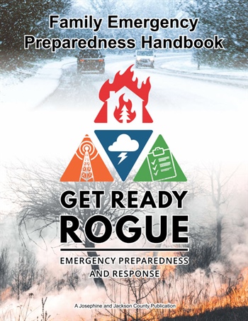
News & Information; Resources; Natural Hazard Mitigation Plan - Get Ready Rogue: Emergency Preparedness and Response
Family Emergency Preparedness Handbook; Jackson & Josephine Counties; .pdf; 52 pp. 4/2021  Rogue Valley Emergency Management (RVEM): Jackson & Josephine Counties
Citizen Alert; Incident Info; Get Ready Rogue: Know Your Hazards; Preparedness Fundamentals;
Special Considerations; Kit Types; Resources; Preparedness Calendar; Prep U- Oregon: Office of Emergency Management (OEM); publications
- National: ready.gov;
Are You Ready? An In-depth Guide to Citizen Preparedness .pdf; 11/2021 - redcross.org
Disaster Preparedness: Emergency vs. Disaster
Disaster Preparedness: Emergency vs. Disaster
Emergency | Disaster | Natural Disasters | Human-caused Disasters |
Measuring Disasters / Mapping Risk | Possible Responses? |
Levels of Response: Preparedness, Policies, Plans, Resources
Emergency
- An emergency occurs usually suddenly, at an individual / local level,
and requires immediate professional attention: - e.g., Medical Emergencies: heart attack, stroke, accident
- e.g., Home Fires
- Your Actions: call 911
- Responders: Local Fire, Paramedics, Police

Evacuation Planning Strategies and Solutions
Disaster
- Hazards are events that pose a risk to vulnerable societies.
- Disasters are major disruptions caused by hazards.
- A disaster affects more people than an emergency,
often with large-scale destruction of life and property - Some areas of Oregon have experienced one or
more of these natural disasters: Earthquake, Wildfire, Flood,
Heat, Hurricane (Typhoon), Landslide, Thunderstorm, Tornado,
Tsunami, Volcano, Winter Storm - Our focus here: natural disasters expected in the Rogue Valley:
Wildfires (and Smoke), Earthquakes, Floods [sections 6-9] - Your Actions: keep you and family safe; get informed;
follow your plan; rely on your own resources until other help is available. - Responders:
- Local Fire, Paramedics, Police are likely overwhelmed for a significant period of time
 Family & Neighbors check on and care for each other,
e.g., Map Your Neighborhood (MYN)- Trained Volunteers assist & augment local emergency personnel and city staff,
e.g., Ashland CERT (Community Emergency Response Team), Ham radio operators - Regional, state and federal governmental and relief organizations provide and coordinate staff and resources,
e.g., Rogue Valley Emergency Management (RVEM);
Oregon Office of Emergency Management (OEM); Federal Emergency Management Agency (FEMA);
note: most "Emergency" Management organizations can scale-up to handle "Disasters"  "Save the Earth?
Earth will be just fine (it’s seen worse).
It’s ourselves we have to save." ~Karen Grove,
our local OLLI geologist, highlighting who's really
harmed by climate change or natural disasters.- The quotes (on right) are from a presentation by James Roddy,
Oregon Department of Geology and Mineral Industries
(DOGAMI) about Disaster Risks: volcanoes, tsunamis,
and especially Cascadia earthquake  Each disaster label below links to description on ready.gov
- Ashland Emergency Preparedness
Evacuation Zone; Evacuation Levels; Get Ready; Wildfire Info; Fire Adapted Ashland;
Chamber of Commerce Preparedness Toolkit; Smokewise Ashland; Nat. Weather Service - Jackson County Emergency Management
Citizen Alert; Wildfire & Smoke; Get Ready Rogue; Jackson County Plans;
News & Information; Resources; Natural Hazard Mitigation Plan - Rogue Valley Emergency Management (RVEM): Jackson & Josephine Counties
Citizen Alert; Incident Info; Get Ready Rogue: Know Your Hazards; Preparedness Fundamentals;
Special Considerations; Kit Types; Resources; Preparedness Calendar; Prep U - Other information may be included from organizations above
CERT, OEM, DOGAMI, FEMA -- acronym overload!;
plus Ashland Fire&Rescue (AFR), American Red Cross (ARC);
NASA; Nat. Oceanic and Atmospheric Admin. (NOAA);
Nat. Weather Service (NWS); US Geological Survey (USGS); ...
 Natural Disasters
- Avalanche; Wikipedia
- Drought; ARC; USGS; NWS, drought.gov
- Earthquakes; OEM, OEM:Cascadia;
Cascadia Playbook .pdf; 2018;
The Oregon Resilience Plan -- Cascadia:
Oregon’s Greatest Natural Threat .pdf; 2/2013
Living on Shaky Ground: How to survive earthquakes and tsunamis in Oregon .pdf; 2018
DOGAMI, Cascadia video;
Wikipedia; CERT video 1:41;
ARC; NASA; USGS; Pacific Northwest Seismic Network - How to Survive a Devastating Earthquake -- and Firestorm and other disasters; Wired; 6/15/2023
- Extreme Heat, Extreme Cold; OEM; ARC: Heat Wave, Winter;
NASA: Severe & Winter Weather;
NWS: Heat, Cold, Winter, Excessive Rainfall and Winter Weather;
NWS to phase out 'advisory' forecast term too vague; Mail Tribune; 3/8/2021;
Wikipedia: Blizzard, Freezing rain, Heat Wave;
CERT videos: Heat Wave 2:00, Winter 1:37;
Everything You Should Do Now to Plan for a Winter Weather Blackout LH; 2/7/2022 - Floods; OEM; DOGAMI; ARC; NASA;
NWS, National Rivers; USGS; Wikipedia; CERT video 2:50; course section: 9. Flood - What Should You Do When You're Expecting the Apocalypse?
in a small town in Kentucky, an immense replica of Noah's ark looms over the countryside; NYT; 1/5/2021 - Hurricanes, Cyclones, Typhoons; ARC; NOAA; NASA; NWS; Wikipedia;
CERT video 1:31; Pacific NW Columbus Day Storm, aka Typhoon Frieda 1962 - The Safest Places to Be During a Hurricane LH; 8/18/2023
- Landslides; DOGAMI; ARC; NASA; USGS; Wikipedia;
CERT video 5:37; course section: 9. Flood:Landslides - Space Weather solar electromagnetic bursts; NWS, forecasts
- Thunderstorms & Lightning; ARC; NWS: Thunderstorm, Lightning, forecasts;
Wikipedia: Lightning ; CERT video 2:29 - What to Do If You're Struck by Lightning (and How to Avoid It) LH; 7/7/2022
- Tornadoes; ARC; NWS: Tornado, Wind, forecasts; Wikipedia; CERT video 1:30
- Tsunamis; OEM; DOGAMI; ARC; NWS, tsunami.gov;
Wikipedia; CERT video 3:18 - Volcanoes; OEM; DOGAMI; ARC; NASA; USGS; Wikipedia; CERT video 7:31
- Wildfires; OEM; AFR; ARC; NASA; NWS, Fire Weather;
USGS; Wikipedia; CERT video 1:37;
course section: 6. Wildfire - One disaster can trigger a domino effect --
immediate or delayed -- of compound, cascading disasters
e.g., Earthquake => Floods / Tsunami => Landslides ...
Drought / Lightning => Wildfires ...
Climate Change => ?? - A seemingly remote disaster can still lead to local problems,
e.g., Wildfires in California or Siberia => severe smoke in Rogue Valley
Volcanoes in Cascades => ash, fires in Rogue Valley - "Should I Stay Or Should I Go?" ~The Clash
- Different strategies & timeframes for different disasters & situations:
[Stay] shelter-in-place: e.g., earthquake, winter storms;
[Go] evacuate (if in harm's way): e.g., wildfire, flood - Although there are some unique considerations specific to each disaster,
the same general planning, organization and preparation
for floods, wildfires, earthquakes and severe weather
can apply to many disasters and situations, regardless of scope.
course section: 8. Earthquake
Human-caused Disasters
 NFPA Hazard Diamond with most labs, the hushed horror stories are about something like dimethylmercury
or prions, but occasionally you'll get a weird lab where it's about the soda machine or the drop ceiling; XKCD.com- Air Pollution Kills 10 Million People a Year.
Why Do We Accept That as Normal? NYT; 7/8/2022 - Biohazard / Bioterrorism; Wikipedia
- Chemical / HazMat; ARC
- Climate Change / Resilience: fema.gov; ARC;
Ashland Climate & Energy Action Plan; 3/2017 - Cybersecurity
- Explosions
- Hazardous Materials (HazMat); Wikipedia
- Industrial Incidents: NASA
- Radiation; ARC; Wikipedia; CERT video 2:04
- What to Do If a Nuclear Missile Hits Your City LH; 7/12/2022
- Oil Spills: NASA
- Pandemic / Infectious Disease / Biohazards;
CERT video 4:57 - Power Outages / Utility Failure; ARC; Wikipedia
- Terrorism: Mass Attacks in Crowded, Public Spaces; ARC; Wikipedia:Civil Unrest
 Other Disasters
- Some disasters may be memes, imagined, exaggerated, planet-wide, civilization-threatening,...
- Alien Invasions
- Asteroids / Comets / Meteors
- How Worried Should You Be About a Space Rock Destroying the Earth? LH; 7/18/2022
- 'Don’t Look Up' Review: Tick, Tick, Kablooey NYT; 12/23/2021
- An Asteroid Impact Simulation Is Currently Underway
-- and It’s Absolutely Terrifying Giz; 4/28/2021 - How to Survive a Killer Asteroid Wired; 4/9/2021
- Killer Bees / Murder Hornets
- Oreo Built a 'Doomsday' Vault to Protect Its Recipe and Cookies
the Global Oreo Vault is just down the road from the famed Svaldbard Global Seed Vault in Norway;
it holds just “the Oreo recipe and a large stockpile of cookies” -- BYO milk;
coordinates: 78° 08’ 58.1” N, 16° 01’ 59.7” E; 10/26/2020 - Zombie Attacks (CDC)
- The Apocalyptic Events You Should Actually Worry About
AI, pandemic, nuclear holocaust, ecosystem collapse; LH; 9/21/2023 - The Real Difference Between the 'Apocalypse,' 'Armageddon,' and 'Doomsday'
apocalypse: a supernatural being reveals mysteries or the future to a human, imminent cosmic cataclysm;
armageddon: location of the final battle between earthly evil and God, as laid out in the New Testament;
doomsday: last day of the world’s existence or, more broadly, a time of great danger;
LH; 10/7/2022
Measuring Disasters / Mapping Risk
- Cassandra: daughter of Priam with the gift of prophesying,
e.g., misfortune or disaster, but fated never to be believed. - Unlike Cassandra, we can predict only the likelihood of
disasters, but based on past history, climate change trends,
and human folly, we can expect more to occur,
with increased intensity and impact. - Like Cassandra, scientists' warnings might be treated
as "false alarms" or "fake news".  Can qualitative English words
accurately convey scope and seriousness of a disaster?- e.g., Accident, Act of God, Adversity, Apocalypse, Armageddon,
Big Bummer, Calamity, Catastrophe, Collapse, Debacle, Devastation,
Doomsday, End-Time, Epic Fail, Fiasco, Holocaust, Major Mishap,
Misfortune, Nightmare, Paroxysm, Ruination, Tragedy, Upheaval, World of Woe, ... - Quantitative measures: intensity (Category: on right),
size of area, # casualties, $ damage, ...? - Many sites list / map past & current disasters and risks:
- FEMA Disaster Declarations:
search by state, year, incident type, declaration type; interactive map - FEMA National Risk Index (NRI);
Counties Map; Jackson County results .pdf
The National Risk Index is an online tool to help illustrate the nation's
communities most at risk of natural hazards. It is made possible through
a collaboration between FEMA and dozens of partners in academia; local,
state and federal government; and private industry. The Index leverages
best available source data to provide a holistic view of community-level
risk nationwide by combining multiple hazards with socioeconomic and
built environment factors. It calculates a baseline relative risk measurement
for each United States county and census tract for 18 natural hazards, based
on Expected Annual Loss, Social Vulnerability, and Community Resilience.
The 18 natural hazards included are: Avalanche; Coastal Flooding;
Cold Wave; Drought; Earthquake; Hail; Heat Wave; Hurricane; Ice Storm;
Landslide; Lightning; Riverine Flooding; Strong Wind; Tornado; Tsunami;
Volcanic Activity; Wildfire; Winter Weather - National Center for Disaster Preparedness: US Natural Hazards Index
visualize historical and projected data for numerous natural hazards [below right] - inciweb.nwcg.gov an interagency all-risk incident information management system
- National Weather Service (NWS): Weather Related Fatality and Injury Statistics: 1996-2019
- National Oceanic and Atmospheric Administration (NOAA): Natural Hazards Viewer;
Severe Weather  preventionweb.net (UN Office for Disaster Risk Reduction): Disaster Risk
- EM-DAT: The International Disaster Database Centre for Research on the Epidemiology of Disasters (CRED)
- ourworldindata.org: Natural Disasters Data
*OFDA: USAID: Office of U.S. Foreign Disaster Assistance - Wikipedia: List of Disasters in the United States by death toll;
List of accidents and disasters by death toll;
List of countries by natural disaster risk - worldatlas.com: Most Prone to Natural Disasters: Countries; US States (data from EM-DAT)
- Category:Lists of disasters
- Emergency and Disaster Information Service (EDIS) event list & map
- USGS: National Geologic Map Database
- NIH Public Health Emergency and Disaster Research Response (DR2)
- ESRI Disaster Response Program
- globalincidentmap.com
- Statista: Natural disasters in the U.S. - Statistics & Facts some free summaries; 9/9/2020
- These Interactive Tools Reveal Your Home's Future Flood, Heat, and Wind Risk LH; 3/13/2023
- What Happens When a Cascade of Crises Collide? global polycrisis, systemic risk; NYT; 11/13/2022
- 'Do You Really Want to Rebuild at 80?' Rethinking Where to Retire. NYT; 11/18/2023
- To see climate risks your home faces, check out two new tools:
Risk Factor Pro (free for 1st yr);
Climate Risk and Resilience Portal (ClimRR);
Verge; 11/7/2022 - These US states are the most vulnerable to climate change
FL; CA; LA; TX; MS; CNet; 11/1/2021 - U.S. Disaster Costs Doubled in 2020, Reflecting Costs of Climate Change
$95 billion in damage came in a year marked by a record number of named Atlantic storms,
as well as the largest wildfires recorded in California; NYT; 1/7/2021  Every Place Has Its Own Climate Risk. What Is It Where You Live?
enter a county; climate risk only -- no earthquakes, etc. NYT; 9/18/2020 [on right]- Mapping America’s wicked weather
and deadly disasters Wash Post; 4/25/2019
Possible Responses to Disasters?
- “There is only one kind of shock worse
than the totally unexpected:
the expected for which one has refused to prepare.”
~ Mary Renault, The Charioteer - Procrastinate, Pray, Panic, Humor; Apocalypse Bingo
- Wealth: the well-to-do will do quite well (don't worry about them).
- Off-the-grid, island villa / bunker? Doomsday prepping?
- What Does It Take to Build a Disaster-Proof House?
a few homeowners across the country are trying to find out, by experimenting with new (and old) construction techniques; NYT; 11/12/2021 - Will These Places Survive a Collapse? Don’t Bet on It, Skeptics Say. NYT; 8/3/2021
- The Island Brokers Are Overwhelmed NYT; 10/9/2020
- Natural Disasters by Location: Rich Leave and Poor Get Poorer
each big catastrophe like a hurricane increases a U.S. county's poverty by 1 percent; SciAm; 7/2/2017  Denial: "It wasn't bad; I've seen worse."
- 'Don’t Look Up' Review: Tick, Tick, Kablooey NYT; 12/23/2021
- Pollyanna: someone foolishly or blindly optimistic
- Migrate: to where the 'grass is greener';
'pick your poison': experience different disasters - If you did find someplace that's safer now,
e.g., Measuring Disasters / Mapping Risk,
might it be affected later by climate change? - Distraction: games, movies, puzzles, etc.
- Play Pandemic board game
- Watch disaster films, e.g., Andromeda Strain,
Armageddon, Avalanche, Don't Look Up, Twister, etc. - video: A Quake! A Quake! Animaniacs; 2:25
- Solve crossword puzzles during pandemics, wars, etc.;
there are also many puzzles about disasters and response. - Emergency! [partial solution]; .pdf;
many clues: "Call ___!" for various real and fictional responders ;-)
[on right] Merl Reagle; Sun, 1/31/2021 - NYT Learning Network: Disasters; Earthquakes;
Hurricanes; Volcanoes; Weather; Winter Weather - 74A. "This is the focal point / Above a seismic source /
Where an earthquake proceeds / With devastating force"
= EPICENTERPOEM [solution] Wash. Post; Sun, 2/21/2021 - Steve's crosswords: MYN; CERT; Red Crossword
- Misc. disaster preparedness (mostly free-form) puzzles:
#1 p.18; #2 p. 87; #3; #4; #5; #6; #7;
#8; #9 p. 7; #10 p. 8; #11


Natural Disaster Awareness for Community Leaders
Levels of Response: Preparedness, Policies, Plans, Resources
- A plan is great to have -- but ask your elected officials how often it's updated,
whether the recommendations are being implemented,
and how often disaster exercises or simulations are held. - National: ready.gov, videos;
fema.gov: A Whole Community Approach to Emergency Management:
Principles, Themes, and Pathways for Action 12/2011 - Ashland City Councilor appointed to FEMA advisory council
Tonya Graham one of 12 appointees to the FEMA National Advisory Council; 12/2/2021 - State: Oregon Office of Emergency Management (OEM): oregon.gov/OEM/
- Emergency Operations Plan: Basic, Complete 3/2017;
Climate Change & Public Health - The Oregon Resilience Plan -- Cascadia:
Oregon's Greatest Natural Threat; 2/2013 - City / County / Regional
- Ashland Emergency Preparedness
Evacuation Zone; Evacuation Levels; Get Ready; Wildfire Info; Fire Adapted Ashland;
Chamber of Commerce Preparedness Toolkit; Smokewise Ashland; Nat. Weather Service - Jackson County Emergency Management
Citizen Alert; Wildfire & Smoke; Get Ready Rogue; Jackson County Plans;
News & Information; Resources; Natural Hazard Mitigation Plan - Rogue Valley Emergency Management (RVEM): Jackson & Josephine Counties
Citizen Alert; Incident Info; Get Ready Rogue: Know Your Hazards; Preparedness Fundamentals;
Special Considerations; Kit Types; Resources; Preparedness Calendar; Prep U - Response to Almeda, Obenchain Fires focus of study funded by Jackson County
report to be presented to Board of Commissioners in 4-6 months; 12/30/2020 - Rebuilding After A Wildfire? Most States Don't Require Fire-Resistant Materials
JC, Medford, Ashland building codes; quotes from AFR's Ralph Sartain; NPR; 11/25/2020 - course section: 2. Ready, Set, Go!
 City
City- Central Point: Hazard Mitigation Plan 9/2020 (draft)
- Eagle Point: Emergency Operations Plan 4/2013
- Jacksonville: Emergency Operations Plan 3/2004
- Medford: medfordoregon.gov/beprepared: evacuation zones; evacuation checklist;
Citizen Alert; neighborhood travel routes; preparedness tips - Medford launches new disaster tools MailTrib; 5/12/2021
- Preparedness; Evacuation Zones 6/2012
- Phoenix: Emergency Operations Plan 8/2013
- Shady Cove: Emergency Operations Plan 5/2012
- Talent: Emergency Operations Plan .pdf; 5/2012
 Ashland: ashland.or.us/evacuate: 10 Evacuation Zones; Alerts; Get Ready; FAQ
- Emergency Operations Plan; .pdf; 7/31/2018
e.g., building codes & zoning, emergency planning, evacuation routes, education, disaster drills/scenarios - Almeda After Action Review (AAR): Lessons Learned; .pdf; 30 pp; 12/2020;
based on: Almeda Fire Public Engagement Survey Presentation; Ashland Council Study Session; .pdf; 333 pp; 11/30/2020 - Ashland and Fire District 3 collaborate to build synergy in fire and emergency response service .pdf; 11/2/2020
- Climate & Energy Programs; Forest Resiliency; Firewise: ashlandfirewise.org;
 course section: 6. Prepare for Wildfire
 - CERT: ashlandcert.org
- Neighborhood: Map Your Neighborhood: ashland.or.us/myn;
course section: 10. Get Involved: CERT, MYN  Individual / Family / Household: recommendations and resources:
Ashland is Ready (AIR): ashland.or.us/air
Emergency Preparedness Guidebook .pdf, 2017
-- followed, updated, expanded in this course (next 11 sections)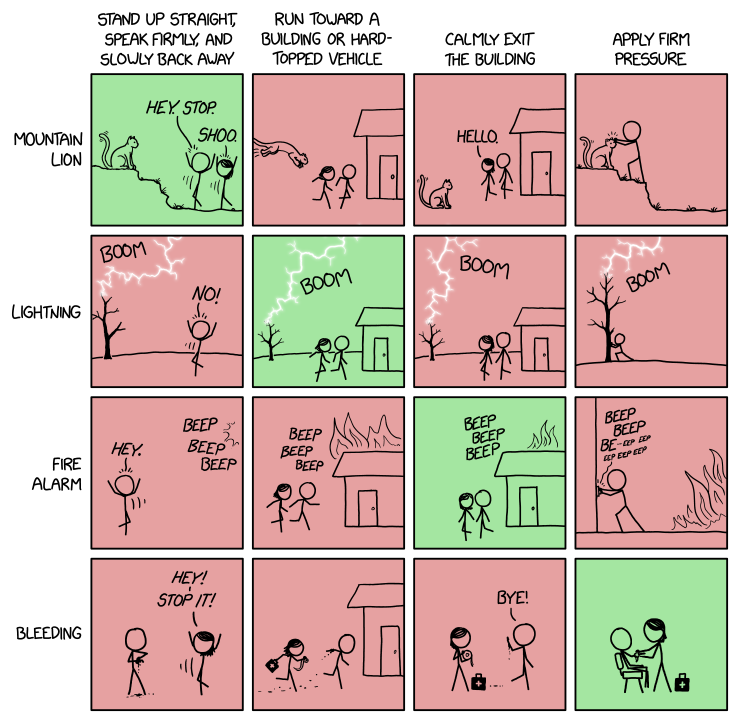 What to Do FYI: The 'drop, cover, and hold on' advice only applies to earthquakes.
If you encounter a mountain lion, you should absolutely not drop to the ground,
crawl under it, and hold on to one of its legs; XKCD.com- Multi-use emergency response center at Expo to break ground
commercial kitchen, shower facilities included in roughly 120,000 sq. ft. facility; RVT; 1/26/2024 - America's Disaster Recovery System is a Disaster NYT; 10/28/2023
- How Wirecutter's Experts Approach Emergency Preparation Coverage NYT; 10/3/2023
- This Is How To Survive Disaster: 6 Secrets From Research 9/2023
- Like Finland, Imagine Everything That Could Go Wrong NYT; 2/13/2023
- Preparing Financially, Before the Storm Hits cost and frequency of weather-driven
disasters on the rise; NYT; 9/9/2022 - How to Prepare for a Disaster, Emotionally and Mentally Wired; 8/23/2021
Disaster Preparedness: 1. Be Informed: Alerts and Communications
Disaster Preparedness: 1. Be Informed: Alerts and Communications
Introduction | JC Citizen Alert |
Emergency Alert Systems: EAS, WEA, ShakeAlert |
Sirens | In-person | Phones; Texting |
TV; Radio | Official Websites; Social Media | Apps
Public domain, via Wikimedia Commons"
Make sure your NOAA radio is properly set
so you will be notified about disasters or severe weather.
Introduction
- An authorized public safety official is available and
creates a message to distribute. Message sent? - A resident has a working device. Turned on?
Message received and noticed?
Language and content understood? - Electricity, landlines, cell towers and/or internet
may be down or unreliable/overloaded. - Do you have redundant ways to receive alerts and trustworthy info,
especially if your preferred ways aren't accessible? - Understand the evacuation levels (next section) used in communications:
 Level 1: Be Ready -- you have a plan; monitor emergency info; know what to take, start to pack
- Level 2: Set -- everything packed at front door or already in car
- Level 3: Go -- evacuate now!
- ready.gov: Alerts, Get Tech Ready
 Jackson County Citizen Alert (Everbridge): rvem.org
Ashland
- Ashland has switched to Citizen Alert (like Jackson County) from earlier "Nixle" system;
some historical (Almeda) info is included. - Ashland citizens are encouraged to create a new account with Citizen Alert replaces Nixle; Ash; 8/11/2023
- Sign up here: ashland.or.us/alerts for most options;
Text:97520 to 888777to sign up for emergency text Alerts, only - optional: Text:
WATERSHED to 888777for Controlled Burn Alerts - Nixle Messages 9/8/2020 - 9/11/2020
- Almeda After Action Review (AAR):
Lessons Learned, .pdf; 30 pp. 12/20; some of the Ashland survey questions:
Were you enrolled in Nixle before the Almeda Fire on Sep. 8th?
Did you find the Level of communication through Nixle to be adequate during the Almeda Fire’s active phase?
How did you access Almeda Fire resources or informational updates from the City?
How could the City have improved its notification process for you?
During the Almeda Fire, were you ever personally advised to evacuate immediately?
Elsewhere in Jackson County
- 1. listed landlines called automatically; "reverse 911"
 2. Text:
 JACKSONEVACS to 888777to sign up
for emergency text Alerts, only- 3. Sign-up: rvem.org or jacksoncounty.org/alert for email, text and/or voice alerts;
be sure to Edit and check alert options [on right]; Josephine County also - video: How to sign up for Citizen Alert for evacuation notices
 and why not to wait for someone to knock on your door
 - Talent: Citizen Alert -- Sign Up Today!
- Citzen Alert uses the Everbridge system (Wikipedia).
- Sign-up for Special (Senior or Disabled) Assistance during/after a disaster:
Rogue Valley Council of Governments: Disaster Registry: rvcog.org
 Emergency Alert Systems EAS: TV, Radio: WEA: Cell phones; ShakeAlert
- e.g., AMBER, Presidential, severe weather alerts, ShakeAlert, Citizen Alert (Everbridge)
- Integrated Public Alert & Warning System (IPAWS): FEMA's national system for local alerting
that provides authenticated emergency and life-saving information to the public
through mobile phones using Wireless Emergency Alerts (WEA),
to radio and television via the Emergency Alert System (EAS), and
on the National Oceanic and Atmospheric Administration's Weather Radio (NOAA). - fema.gov: EAS, WEA; weather.gov: NOAA
 ready.gov: EAS, WEA, NOAA; fcc.gov: EAS, WEA
Emergency Alert System (EAS)
- EAS (TV/Radio) : national public warning system commonly used
by federal, state and local authorities
to deliver important emergency information,
such as weather and AMBER alerts, to affected communities
via broadcast & satellite radio and TV providers,
cable systems, and wireline video providers. - TV or radio: turned on, volume audible?

 Wireless Emergency Alerts (WEA)
- WEA: critical warnings and information
from authorized public safety officials
to the public in affected areas on their wireless devices - Some of these alerts might look like text messages but
they are not, and are thus not affected by network congestion
that may affect regular mobile voice or text messaging services. - The alert is accompanied by a unique attention signal and vibration,
which is particularly helpful to people with hearing or vision-related disabilities. 
 Cell phone: powered on; Airplane Mode: off; within cell tower range;
emergency notifications: enabled [right: Android, iOS]?- You should receive and hear notifications even if you've
enabled Do Not Disturb, blocked unknown callers, or used the mute button. - Everbridge has been IPAWS-certified by FEMA,
so notifications via Citizen Alert should also be received,
assuming the same phone settings above. - FCC: How to Opt In to Wireless Emergency Alert Tests And, iOS; .pdf
- Nationwide Alert Will Reach Cellphones, TVs and Radios on Wed (10/4/2023) NYT; 10/4/2023
- Maui Sent an Evacuation Alert. Why Did So Few People Get It? shortcomings of a wireless alert system; NYT; 9/3/2023
- Emergency SOS via satellite: Where and how the life-saving iPhone feature works MW; 3/7/2023
- "Huge flaw" threatens US emergency alert system, DHS researcher warns
hackers can disrupt legit EAS (TV/radio) warnings or issue fake ones of their own; Ars; 8/4/2022 - Why your iPhone didn’t get the August 2021 wireless emergency alert test
Android phones have a toggle for emergency alert tests in Settings,
iPhones do not -- manually call: *5005*25371#; MW; 8/16/2021 - Use Emergency Bypass to Circumvent Do Not Disturb for VIPs
Contacts > (Citizen Alert #) > Edit >

Ringtone and/or Text Tone > Enable Emergency Bypass > Done
iOS; TidBits; 4/1/2021 - Texas Department Apologizes for 'Chucky' Amber Alert test; NYT; 2/3/2021
- Some in the Path of Oregon's Wildfires Never Got Evacuation Alerts
local officials declined to activate their Emergency Alert System,
leaving television and radio programs uninterrupted
and sending emergency alerts only to residents who had signed up
for an online notification system; NYT; 9/25/2020 - County defends decision to not use mass emergency alert system for Almeda fire
Citizen Alert notification system can warn people in a specific area, like Talent and Phoenix,
as opposed to the whole county -- assuming people without landlines have enrolled; KOBI5; 9/16/2020 - Hawaii Panics After Alert About Incoming Missile Is Sent in Error NYT; 1/13/2018
- Inside the Decades-Long Fight for Better Emergency Alerts Wired; 11/14/2017
 ShakeAlert
- "Earthquake Detected! Drop, Cover, Hold On. Protect Yourself. -USGS ShakeAlert"
- "Terremoto detectado! Agachese, cubrase, sujetese. Protejase. -USGS ShakeAlert"
- ShakeAlert from USGS is an
earthquake early warning (EEW) system that
detects significant earthquakes so quickly that
alerts can reach many people before shaking arrives. - ShakeAlert is not earthquake prediction,
rather a ShakeAlert Message indicates that an
earthquake has begun and shaking is imminent. - Based on location and the magnitude of
P-wave (primary, pressure) information from sensors,
the method can provide warning seconds*
before slower S-wave (secondary, shear,
side-to-side, surface) arrives, bringing the strong shaking
that usually causes most of the damage. - *Number of seconds of warning depends on location of epicenter,
rock types, speed of signal detection & processing, message distribution:
:00 -- at OR Coast (seismometers on land, rather than deep offshore)
:20-:30 -- in Rogue Valley for Cascadia event off So. OR coast
:30+ -- in Rogue Valley, if epicenter farther north - If ShakeAlert is enabled in your area, i.e., CA (10/2019), OR (3/2021), WA (5/2021),
messages are sent via: WEA (emergency alerts) or a ShakeAlert app - Note: WEA is sent out via a different protocol.
WEA delivery had been measured in 10s of minutes but hopefully improving; app should be faster.
WEA is a general alert sent out to a very wide area but can reach more people w/o an app install.
The app alert will be specific to the user since it knows the location.
Both are needed in order to deliver the most alerts they can. - Phone OS may provide built-in alerts and detection (accelerometer as mini-seismometer);
Android 5+: integrated support;
iOS: 3rd-party seismometer apps only, currently? - Slightly different alerting thresholds for the different alert delivery types (from Eric Ditmer):
- Wireless Emergency Alerts (WEA): M5.0+ and MMI 4+
- apps, Android: M4.5+ and MMI 3+
- M = Magnitude (Richter, etc.); MMI = Modified Mercalli Intensity;
comparison: M vs. MMI - video: 4:38; shakealert.org; note: QuakeAlertUSA app is no longer available
- Seconds before a 6.2 earthquake rattled California, phones got a vital warning
ShakeAlert; Guardian; 12/21/2021 - Entire U.S. West Coast Now Covered By
Earthquake Early Warning System NPR; 5/5/2021 - Earthquake early warning now available to Oregon public
Governor Kate Brown today proclaimed 3/11/2021 as
ShakeAlert Day, in recognition of the activation of the
ShakeAlert Earthquake Early Warning System in Oregon,
and the day that coincides with the 10th anniversary of
the magnitude 9.1 Great Tohoku, Japan earthquake.
Alerting is now available directly to individual wireless
devices in Oregon -
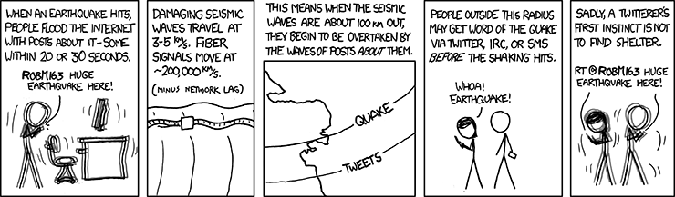
Seismic Waves by XKCD is licensed under a
Creative Commons Attribution-NonCommercial 2.5 LicenseShakeAlert in Oregon oregon.gov/oem; 3/11/2021
- Oregon's ShakeAlert Earthquake Warning System
Approved for State Funding
legislature approved $7.5 million to fund Oregon’s ShakeAlert
system during their one-day special session; NPR; 8/11/2020 - 5 new things your Android phone can do:
#2. Get alerted to earthquakes around you
Android 5.0 and above, devices with accelerometers; 8/11/2020
 Sirens
- Sirens can be highly effective if heard and the meaning is clear,
i.e., what is the disaster, who is affected, what to do / where to go? - At a minimum, sirens can provide a "wakeup call" if you or your devices are asleep.
- Check trusted sources for further info and guidance, e.g., Citizen Alert, official web sites, Radio, etc.
- In tornado zones, a siren means: tornado! go to your shelter now.

 In Ashland, sirens (=~4) audible in the flood zone along
Ashland Creek are followed by one of these messages
about Hosler Dam (at Reeder Reservoir):- 1. "This is a test of the Hosler Dam warning system.
This is only a test." - 2. "Hosler Dam Emergency.
Evacuate the flood hazard zone immediately." - 3. "Hosler Dam is secure.
It is safe to return to the flood hazard zone." - Hosler Dam Early Warning System .pdf; includes flood zone map
- video: Ashland tests Hosler Dam flood warning sirens 0:40
- Other creeks and tributaries can flood: Jackson County Floodplain Maps
In-person Notification
Before a Disaster
- Public Safety Officers (police, fire) may drive along streets with sirens or loudspeakers.
- If safe, available officials and CERT Volunteers may systematically canvass neighborhoods door-to-door.
- If you received an official notification, e.g., Citizen Alert,
contact nearby neighbors who are unaware, may not understand English or may need extra assistance;
e.g., their needs shared earlier via Map Your Neighborhood (MYN) - CERT team members alerted MYN neighbors in Talent MYN; Mail Tribune; 11/2/2020
- Don't rely on personal notification -- there may not have been time or personnel available.
If you do receive one personal evacuation warning, don't expect a second visit.
After a Disaster
- MYN neighbors may check on and help each other.
- CERT teams may canvass neighborhoods, survey damage, triage and treat injuries, and perform light search&rescue.
 Phones: Hotlines/Recordings; Texting
- Ashland Wildfire and Smoke:
541-552-2490;
541-552-2378(-CERT): backup for CERT members who missed activation messages - Jackson County: Emergency Management:
541-776-7338;
Civil Emergency Hotline:541-776-7339;
Sheriff:541-774-6800 - Josephine County Emergency Management:
541-474-5305 - 911 may be overloaded / unavailable.
- Hardwired landlines (non-wireless handsets; non-VOIP) may function, even if power is out.
- Cell service -- if available -- will likely be overloaded.
- See WEA above for Wireless Emergency Alerts
- Regular (SMS) texting may be more successful
than voice calls or internet-based messaging. - How to Activate Emergency SOS on iPhone OSXD; 7/28/2021
- some organizations with text messaging options:
Jackson County, e.g., Citizen Alert;
FEMA, e.g., Shelters, Recovery Centers;
Red Cross, e.g., Weather and Emergency Alerts - Here's what it’s like to use Apple's Emergency SOS via satellite Verge; 11/15/2022
 Apple Says More about Emergency SOS via Satellite Technology TB; 11/11/2022
- Apple's Emergency SOS link puts it into the satellite fight with SpaceX and more iPhone 14 and 14 Pro; Verge; 9/8/2022
- Garmin inReach Explorer+ (GPS, map & texting unit; with subscription plan) [on right]
can be used in emergencies to contact search&rescue or family/friends
with pre-composed or custom messages via 2-way satellite texting
-- even when no cellular or internet access is available,
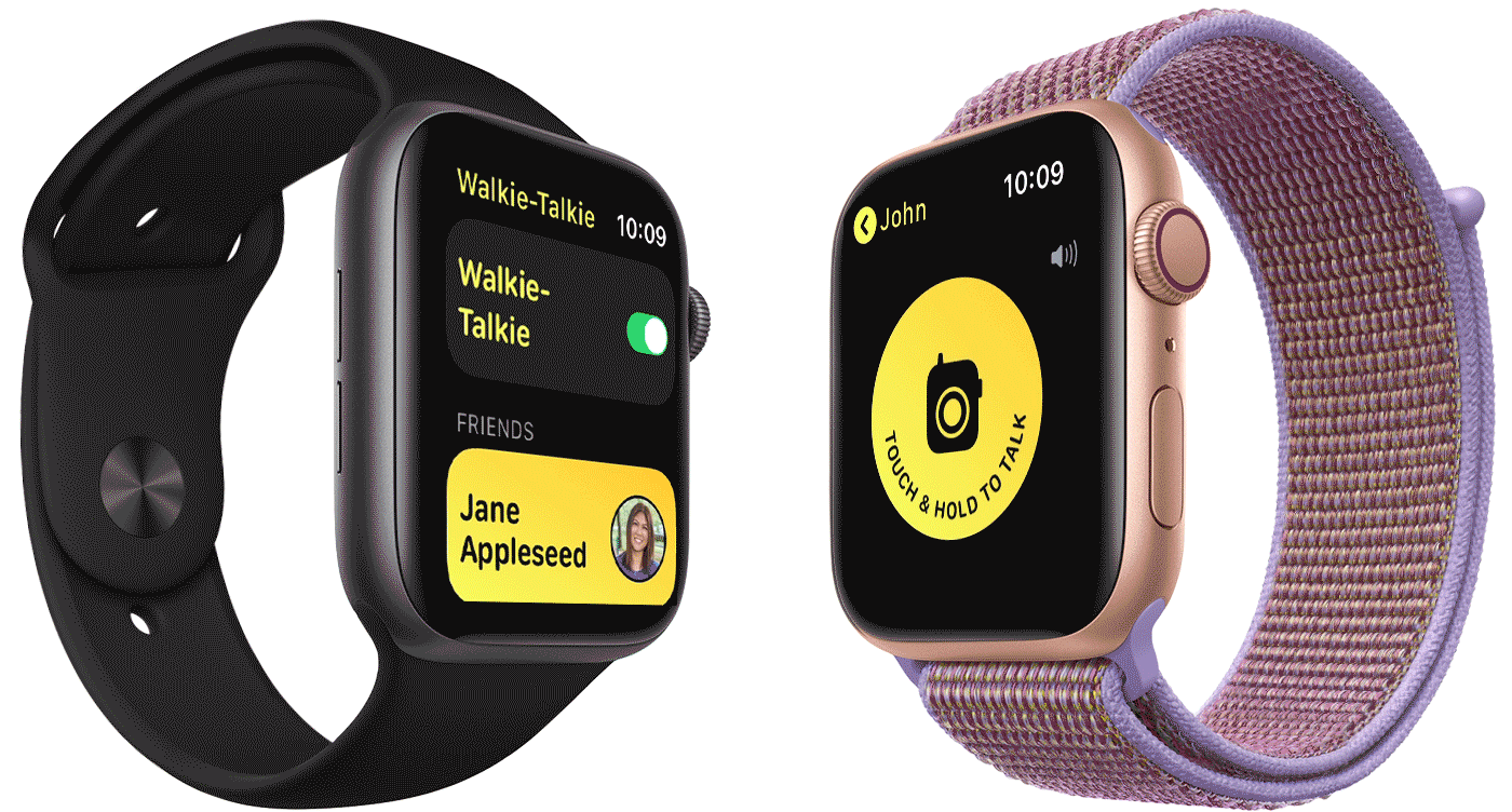
e.g., regional disasters, backcountry, remote roads.  Apple: Use Walkie-Talkie on your Apple Watch watchOS 7 docs;
animated demo; over internet connection from paired iPhone,
or on watch (Wi-Fi or built-in cell capability)
 TV; Radio: AM/FM, NOAA, FRS, GMRS, MURS, Public Safety, Ham, CB
- Ashland Emergency Radio Station: 1700 AM
- Use your car's radio if you don't have a separate battery-operated radio.
- Aside from EAS alerts, general TV & Radio news broadcasts
may not be as current and accurate as other methods. - Blanket evacuation orders may make the disaster worse,
e.g., traffic jams with unnecessary Level 1-2 evacuees. -

Mark Trail Champions NOAA Weather Radio;
www.weather.gov/nwr/In US, FCC oversees these frequencies:
- UHF Ultra High Frequency: 300 megahertz (MHz) to 3 gigahertz (GHz);
wavelengths (band): 1 meter (m) to 0.1 m;
e.g., FRS, GMRS; Ham; broadcast TV; Wi-Fi (2.4Ghz);
cell networks ('3G', i.e., 3rd gen.); cordless phones - VHF Very High Frequency: 30 to 300 MHz; 10 m to 1 m;
e.g., NOAA; MURS; Public Safety; Ham; broadcast TV; FM - HF High Frequency: 3 to 30 MHz; 100 m to 10 m; e.g., CB; Ham ('shortwave')
- MF Medium Frequency: 300 kilohertz (kHz) to 3 MHz; 1000 m to 100 m; e.g., AM
- other frequency ranges: Electromagnetic spectrum
- transmission range (distance) depends on many factors:
more range with lower frequency, higher output power, longer antenna,
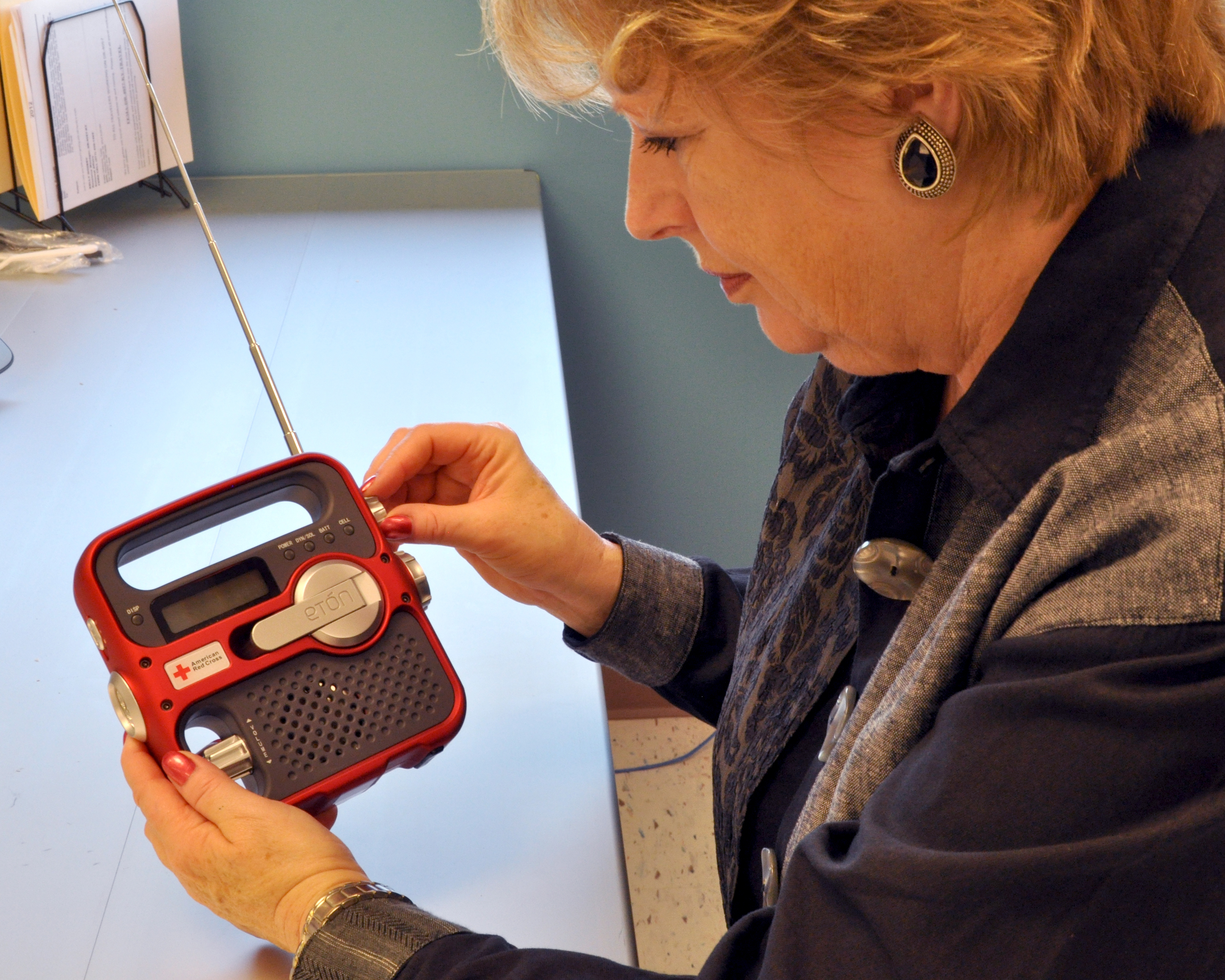
proper radio positioning, fewer line-of-sight obstructions - NOAA Weather Radio All Hazards receive-only; no license required; VHF;
inexpensive; for home and/or go-bag; periodically test, recharge battery;
some models recharge via handcrank, USB and/or tiny solar;
 may have AM/FM stations, flashlight; Wikipedia: NOAA
NOAA stations also avail via Broadcastify - Some walkie-talkies (FRS) include NOAA channels -- check your user manual
- 7 channels should be standard, numbered 1-7, usually named "WX1-WX7"
- NOAA channel; VHF freq. (MHz):
1. WX2: 162.400  (Medford); 2. WX4: 162.425; 3. WX5: 162.450;

4. WX3: 162.475 (Mt. Ashland); 5. WX6: 162.500; 6. WX7: 162.525; 7. WX1: 162.550
additional:161.650; 161.750; 161.775; 162.000; 163.275 - Family Service Radios (FRS) aka "walkie talkies": local, two-way messaging and coordination; UHF;
 low output power: 0.5-2w (short-range); no license required; limited channels; inexpensive; congested?
Wikipedia: FRS; some include NOAA channels -- how to recharge during power outage? - FRS channel (output power); UHF freq. (MHz):
1-7 (2w):462.5625; 462.5875; 462.6125; 462.6375; 462.6625; 462.6875; 462.7125
8-14 (0.5w):467.5625; 467.5875; 467.6125; 467.6375; 467.6625; 467.6875; 467.7125
15-22 (2w):462.550; 462.575; 462.600; 462.625; 462.650; 462.675; 462.700; 462.725 - General Mobile Radio Service (GMRS): frequency overlap* with FRS; UHF;
higher output power -- up to 50w on some frequencies; requires license; Wikipedia: GMRS - GMRS channel (output power); UHF freq. (MHz):
1-7 (5w), 8-14 (0.5w), 15-22 (50w) -- *same FRS frequencies;
additional (50w):467.550; 467.575; 467.600; 467.625; 467.650; 467.675; 467.700; 467.725 - Multi-Use Radio Service (MURS): low power like FRS; no license required; Wikipedia: MURS; VHF
- MURS channel (output power); VHF freq. (MHz):
1-5 (2w):151.82; 151.88; 151.94; 154.57; 154.60 - Citizens Band (CB): no license required; longer range; HF
- Public Safety (PS): police and fire dispatcher traffic; VHF; anyone can listen, e.g., channel scanner;
non-radio access: Broadcastify: Jackson County or apps: Broadcastify, Pulsepoint;
very immediate and unfiltered local operational details -- not a source of advice or context.
 CERT teams may be authorized to transmit on selected channels for official missions and training.
 - Amateur Radio Service aka "Ham"; VHF, UHF, HF; anyone can listen*; live, unfiltered info;
*two-way requires Ham license ('Technician': VHF,UHF; 'General': HF; Morse code no longer tested);
typical form factors, output power: handheld (like FRS; 5w), mobile (vehicle; 25-65w), base station (50-100w);
Jackson Co. (JC) Amateur Radio Emergency Service (ARES); Wikipedia: Ham; Steve: Ham
 Official Websites; Social Media
- Public safety websites should be updated frequently during disaster;
their official social media sites/apps (e.g., FB = Facebook) would be trustworthy,
and may be updated even more quickly
-- assuming home internet or mobile data is available.
Authorized, knowledgeable personnel may not have time to duplicate
information and answer questions on other sites, e.g., NextDoor - Non-official websites and social media may provide advertising, gossip,
rumors, conspiracy theories, etc. -- so are generally not recommended
as reliable sources of disaster news and advice. - Ashland Fire & Rescue: site; FB; CERT;
Ashland Police: site; FB;
City of Ashland: site; FB; Trusted Organizations;
Ashland Forest Resiliency Project: Controlled Burn & Trail Info: ashland.or.us/trailinfo - Medford: Fire Dept. (FB);
Police (FB);
City (FB) - Jackson County: Fire District 3 (FB);
Sheriff: site; FB;
Emergency Management: site; FB - JCEM FB Posts: 9/8/2020 - 9/12/2020; .pdf; e.g., above right
 Live Evacuation Map [right], with links (now inactive):
Missing Persons Form and Evacuation Check In
(another option: RedCross: Safe and Well)- jacksoncountyor.org (backup site: jacksoncounty.org)
- Ransomware attack shuts Jackson County website MailTribune; 11/18/2020
- roguevalley.recovers.org: Preparedness and Recovery Hub.
need? give? volunteer? - roguevalleyrebuilds.org: info from multiple orgs and govt agencies
involved in recovery and rebuilding efforts. - Josephine County: Fire; Sheriff
Emergency Management: site; FB - alertwildfire.org;
Video cameras would let public track urban fires for Jackson & Josephine counties; MailTribune; 5/25/2021 - Oregon: DEQ: Smoke Map / AQI;
ODOT: TripCheck (road conditions / closures) - SW OR District, OR Dept. of Forestry (ODF): swofire.com FB
- Northwest: Inciweb Fire Map
- redcross.org: Safe and Well:
1. Register yourself as "Safe and Well"
2. Search for family or friend (who registered as Safe and Well) to see name & short message - weather.gov: National Weather Service (NWS) Active Alerts/Forecasts;
Drought; Excessive Rainfall and Winter Weather; Fire Weather; Flooding (National Rivers);
Hurricanes; Space Weather; Thunderstorm/Tornado; Tsunamis; UV Alerts
 Apps
Apps
- Many apps can provide emergency & disaster-related information; most iOS and Android.
Communication features assume cell service or internet/local networking available. - PulsePoint notifications provide an early heads-up to local threats
such as wildland fires, floods and utility emergencies;
it can also alert users trained in CPR & AED (Automated External Defibrillation)
for nearby emergencies; feeds via Broadcastify (which also has apps);
separate PulsePoint AED app shows nearest AED units on map - Everbridge Mobile App links to your Citizen Alert subscription.
"See Something -- Say Something: Be the eyes and ears of your community
and share geo-location information, pictures free-form text as a situation develops.
Receive a push alerts from authorized public safety agencies for high-priority messages
sent while in a geo-fenced area. View safety alerts on a map and filter alerts based
on time, priority and source. Designed to reliably work under adverse network conditions,
for example, when bandwidth or connectivity is limited" - ShakeAlert-enabled apps (CA, OR): MyShake
 ready.gov: FEMA app
- Receive real-time alerts from the National Weather Service
for up to 5 locations nationwide. - Share real-time notifications with family via text, email, social media
- Learn emergency safety tips for over 20 types of disasters,
including fires, flooding, hurricanes, snowstorms, tornadoes,
volcanoes and more. - Locate open emergency shelters and disaster recovery centers
in your area where you can talk to a FEMA representative in person. - Prepare for diasters with a customizable emergency kit checklist,
emergency family plan, and reminders. - Connect with FEMA to register for disaster assistance online.
- Toggle between English and Spanish.
- Some FEMA text-only options (w/o app):
- Locate an open emergency shelter in your area. Text:
SHELTER and Zip Code to 43362 - Locate an open Disaster Recovery Center in your area. Text:
DRC and Zip Code to 43362 - Preparedness Tips. Text:
PREPARE to 43362  redcross.org Mobile Apps:
- First Aid: Get instant access to information on handling the most common first aid emergencies
- Emergency: All-inclusive app monitors more than 35 different severe weather and emergency alerts
- Earthquake: Receive notification when an earthquake occurs, find help and
let others know you’re safe even if the power is out - Flood: Learn and prepare your family and friends for flooding, evacuation and a safe return home
- also: Hurricane, Tornado, Pet First Aid and other apps; and options to receive info via text messages
 Zello Push-to-Talk (PTT) Mobile App
"walkie talkie" over cellular or WiFi
(similar to Apple Watch)- 7 Emergency Preparedness Apps to Keep on Your Phone
FEMA; Harbor; First Aid, Hurricane: American Red Cross;
MyShake; Zello; EPA Smoke Sense; Wired; 4/5/2021
Disaster Preparedness: 2. Evacuation Process: Ready, Set, Go
Disaster Preparedness: 2. Evacuation Process: Ready, Set, Go
Introduction | Level 1: Be Ready |
Level 2: Be Set | Level 3: Go!
 The 3 Levels of Evacuation
- Life safety is the primary concern of Ashland Fire & Rescue.
- During a wildfire, residents may be asked to evacuate their homes,
and depending upon the situation, you may have hours or mere minutes to get out. - The Ready, Set, Go! (RSG!) program is utilized by
Jackson County and Ashland Fire & Rescue to help educate residents
on what to expect in the event of a disaster related evacuation. - The levels of Ready, Set, Go! help residents
- 1. Be Ready long before an evacuation,
- 2. Be Set with situational awareness when an emergency threatens,
- 3. Go!, leaving promptly when evacuation orders are given
or when safety feels compromised.
Do not wait and leave late! - Messages and maps use these colors and terminology
- Jackson County: brochure: Be Ready, Be Set, Go
- rvem.org: Ready, Set Go
- Jackson County cities adopt evacuation zones
MailTrib; 6/8/2021 - Evacuation Maps: Jackson County (Live);
Almeda, Obenchain .pdf: 9/2020 - Medford: medfordoregon.gov/beprepared:
Evacuation Zones; Evacuation Checklist; Citizen Alert;
Neighborhood Travel Routes; Preparedness Tips - Ashland: ashland.or.us/evacuate: Alert Levels/Info; Get Ready; FAQ;
10 Evacuation Zones: Know Your Zone, Map .pdf;
Evacuation Time Estimate Study: video: Summary 43:26;
Study Summary .pdf; Study Full Document .pdf; KLD Engineering; 4/2021 - Evacuation Checklist: Go Kit; Before You Leave; Personal Records Binder; Pet Kit;
Irreplaceable Belongings Box; Prepare your family for after the fire (2 Weeks Ready); .pdf - Ashland Evac plan .pdf; 2018
- videos: Be Ready, Be Set, Go intro, 0:52;
Evacuation The 10 Minute Challenge a tale of 2 families, 3:16 - How to Evacuate With Pets NYT; 9/28/2022
- Do This Now in Case You Are Separated From Your Pet After a Disaster LH; 9/9/2022
- Talent: Evacuation Zones / Zonas de Evacuación
 Level 1: Be Ready to Evacuate
- A LEVEL 1 evacuation means “BE READY” for potential evacuation.
- Residents should be aware of the danger that exists in their area,
monitor emergency services websites and local media outlets for information. - This is the time for preparation and precautionary movement of persons
with special needs, mobile property and (under certain circumstances) pets and livestock. - For wildfire, be Firewise by reducing your home's ignition potential.
- Assemble emergency supplies and belongings in a safe place.
- Create an Evacuation Plan with escape routes and
make sure all those residing within the home know the plan of action.
Emergency fire escape ladder (kept under bed) is a good idea for upstairs bedrooms. - Taking the correct route during an evacuation is critical for your safety.
 A Red Flag Warning suggests that Level 2 could be imminent
-- warm temperatures, very low humidities, and stronger winds are
expected to combine to produce an increased risk of fire danger.- Tune into information about where to go during an evacuation, e.g.,
Nixle Citizen Alert System:ashland.or.us/nixle
Ashland Emergency Broadcast Station: 1700 AM
Wildfire Information Hotline: 541-552-2490
City of Ashland Website:ashland.or.us
Jackson County Emergency Management:rvem.org
full list: 1. Be Informed - If conditions worsen, emergency services personnel may contact you
via an emergency notification system. - ALL RESIDENTS SHOULD BE AT THIS LEVEL OF READINESS AT ALL TIMES!
 Level 2: Be Set to Evacuate
- A LEVEL 2 evacuation means “BE SET” to evacuate. Situational Awareness.
- This level indicates there is significant danger to your area, and residents
should either voluntarily relocate to a shelter or with family/friends
outside of the affected area, or if choosing to remain, to be ready
to evacuate at a moment’s notice. - Check road closures: ODOT: tripcheck.com; plan evacuation route.
- If you do decide to stay, pack your emergency items and be ready to leave at a moment’s notice.
- Other advice from CalFire, USFS, e.g., move propane; move flammable materials; etc.
prop open flammable fence gates;
if turning off gas, wait until Level 3 -- since restoring gas service might take days/weeks?? - THIS MAY BE THE ONLY NOTICE THAT YOU RECEIVE.
- Emergency services cannot guarantee that they will be able to notify you if
conditions rapidly deteriorate. Area media services will be asked to broadcast periodic updates.
 Level 3: Go! — EVACUATE now
- A LEVEL 3 evacuation means that you need to LEAVE IMMEDIATELY!
- Danger to your area is current or imminent, and you should evacuate immediately.
- Follow your personal evacuation plan.
- Leave electricity on -- unless emergency responders ask you to turn off.
- Leave lights on -- enables responders to see that no one is inside.
- Close windows and doors -- protects your home by reducing oxygen for fire.
- Leave a note that you've left and where you've gone
-- first responders/neighbors can save time checking, and later inform others who inquire about you. - If you choose to ignore this advisement, you must understand that emergency services
may not be available to assist you further. - DO NOT DELAY leaving to gather any belongings or make efforts to protect your home.
- Be aware of hazards. Take direction from authorities.
- Access to evacuated areas may be denied until conditions are safe for citizens to return.
- DO NOT plan to return to check on your house or animals. If it’s not safe for them, it’s not safe for you!
Disaster Preparedness: 3. Evacuation Planning
Disaster Preparedness: 3. Evacuation Planning
Plan, Prepare and Practice |
Take Direction from Authorities
is licensed under CC BY-NC-ND 2.0
Plan, Prepare and Practice
- Take appropriate steps in planning ahead before disaster strikes.
- Having a plan and being prepared will help reduce stress.
- ready.gov: Make a Plan;
Emergency Alerts and Warnings;
video: Preparing Makes Sense 4:32;
other preparedness videos - Medford: preparedness tips, evacuation checklist
- How to prepare to evacuate
before disaster strikes Mail Tribune; 8/1/2021 - Emergency Preparedness and Resilience Toolkit
1. Prepare the Essentials
2. Inventory Personal Property
3. Evacuation Zones, Routes
4. Understand Your Insurance
5. Store Important Documents;
Ashland Chamber of Commerce; 7/2021 - Pack a ‘Go Bag’ Now
To begin, have a plan.
Pack everyone their own bag.
Know you could be gone for a while.
Break your packing into categories: Clothing; important Paperwork;
Health essentials; Food and Water;
NYT; 9/19/2020 - Communicating with loved-ones will be difficult.
- ready.gov: What is my family/household communication plan? 4/2021

 People and Pets -- Have a plan.
Do you know at least two ways out of your community?
Where will you meet family after evacuation?
Where will you stay and how will you contact each other?
Where will your pets stay?- ready.gov: Older Adults; Kids; Special Needs; Evacuation Route;
Pets or Service Animals; Shelter Plan - Jackson County: Personal and Family Preparedness;
Access and Functional Needs; Pets and Livestock 
 Papers, phone numbers, and important documents.
Deeds, birth certificates and other irreplaceable documents
should be in one location so these can be
grabbed at a moment’s notice.- ready.gov: Emergency Kit; Emer. Financial First Aid Kit
- Everplans: All The Things You Should Consider Taking
With You In An Emergency Evacuation; checklist .pdf 
 Prescriptions, eyeglasses, and vitamins.
You may be gone from your home for days,
so insure you have access to all your health related items.- Credit cards, ATM cards and cash.
- Pictures (not yet scanned or digital) and
irreplaceable memorabilia -- these could be lost forever. 
 Chargers, cables, batteries.
Personal computers, tablets, backup drives
or any info on external media.
Passwords: paper or backed up and encrypted to cloud.
Consider encrypting critical docs onto a web based service.- Any paper or digital info or financial items left behind
-- can't be used by you, but might be found by looters. - ready.gov: Get Tech Ready
- What Belongs in Your Survival Kit, From 8 People Who Know Something About Disasters NYT; 6/1/2023
- Best Home Emergency Kit Gear: Flashlights, Stoves, Chargers, and More Wired; 1/26/2023
- How to build a tech emergency kit ApIn; 9/26/2022
- 14 Essentials You Need in a Car Emergency Kit Wired; 5/18/2022
- How to Stay Safe if You're Trapped in Your Car During a Snowstorm
pack a go bag; stay warm; take care of yourself; pets?
be visible to rescuers; driving when the storm passes; NYT; 1/5/2022 - Preparing for an emergency: How to document your belongings
speed up the insurance claim process by cataloging your possessions in advance; CNet; 11/1/2021 - Is Your 'Go Bag' Ready? 'Stay Bin'? NYT; 9/2/2021
- Emergency Kits MailTribune; 5/17/2021
- How to Pack a 'Go Bag' for Emergency Evacuations LH; 2/1/2021
- OLLI Course: Be Safer on the Internet: Backups: Disaster; Encryption
Take Direction from Authorities
- Know your Zone. Plan several possible evacuation routes.
- Ashland: ashland.or.us/evacuate:
Know Your Zone; Know Your Alerts; Get Ready; Evac. Time Study - Jackson County: Evacuation Zones: Ashland, Medford, Central Point, Talent
- When you are asked to leave your home, Go!
- Always have your disaster supply kit stocked and ready for use.
- Implement your plan just as you’ve practiced
in the past during non-disaster situations. - Stay calm.
- Situational awareness:
be aware of your surroundings such as
downed power lines, fallen objects,
pedestrians and traffic, and
spills or other potential hazards. - Jackson County: Live Evac Map -- with links (now inactive) for:
Missing Persons Form and Evacuation Check In - Almeda, Obenchain Maps .pdf: 9/2020; e.g., on right
- City of Ashland: Emergency Operations Plan 7/31/2018
Disaster Preparedness: 4. Family Disaster Planning
Disaster Preparedness: 4. Family Disaster Planning
Introduction | Fire, Flood or Other Disaster | Plan |
Shelter-in-place | Evacuate
Communication Is The Most Critical Aspect Of Disaster Planning.
Assign Each Family Member A Role.
Consider All Situations Which May Impact You.
Practice Your Plan.
Introduction
- "Forewarned, forearmed; to be prepared is half the victory" ~Miguel de Cervantes
- "The best laid schemes o' mice an' men / Gang aft a-gley, [often go awry]"
~Robert Burns, "To a Mouse" - "Anything that can go wrong will go wrong" ~Murphy's law
- "Mother Nature may be forgiving this year, or next year,
but eventually she's going to come around and whack you.
You've got to be prepared." ~Geraldo Rivera - video: Importance of a Disaster Plan CERT; 3:28
 Fire, Flood or Other Disaster
- Fire -- Practice crawling low under smoke. Practice STOP! DROP! And ROLL!
- Wildfires; OEM; JCEM; AFR; ARC
- see section: 6. Wildfire
- Earthquake -- Practice DROP! COVER! and HOLD ON!
- Earthquakes; OEM, OEM:Cascadia; DOGAMI, DOGAMI: Cascadia video;
JCEM; ARC - see section: 8. Earthquake
- Floods; OEM; DOGAMI; JCEM; ARC
Landslides; DOGAMI; ARC
- see section: 9. Flood
Plan
- Develop a home evacuation plan,
including the use of alternative exits such as windows. - Meeting locations -- you need a location near your home and away from home.
- Informing loved-ones you are safe; will you text them?
How long before they can reasonably expect to hear from you? - Identify an out-of-state contact.
Create a hard copy of relevant Contacts (.pdf) and provide to each family member. - If you can access your voicemail, update your greeting to include information
for those who can call you (even if you can't later access their messages).  Jackson County: Preparedness Plan for Families
- ready.gov: Make A Plan Page
- Family Emergency Communication Form 7/2017
- redcross.org: Create Your Emergency Plan in Just 3 Steps
- Learn CPR and First Aid basics
- Red Cross Family Disaster Plan: Template, Instructions; Plantilla, Instrucciones
- Is Your 'Go Bag' Ready? 'Stay Bin'? NYT; 9/2/2021
- 5 Apps to Prepare You For Any Emergency
Planning: FEMA; Personal and contact info: ICE (In Case of Emergency);
Staying connected: Life360; Treating injuries: Red Cross First Aid;
Protecting pets: Pet First Aid; PC Magazine; 4/27/2020 - other apps: Red Cross: Earthquake, Flood; WebMD; AED; Triage
Shelter-in-place
- In some disasters staying put is safest depending on the situation.
You may need to stay put for extended periods of time. - e.g., Cascadia earthquake could damage roads & bridges and prevent evacuation
-- section: #5. 2 Weeks Ready - You may be without essential services during these times.
- You may be able to rely on neighbors for support if you've met in advance
-- section: #10. Get Involved: Map Your Neighborhood - Know how to seal off a room, if required, and have the proper materials on hand,
e.g., for smoke, cold - Shelter-in-Place Advice
disaster: Active Shooter, Chemical Hazard, Earthquake; Flooding/Flash Flooding;
Hurricane (High Wind, Flooding and Storm Surge); Nuclear/Radiological Event;
Pandemic; Thunderstorm; Tornado; Winter Storm;
structure: Manufactured or Mobile Home; 1- or 2-Story Building (w/ attic and/or basement); Multistory Building;
FEMA; 13pp; .pdf; 5/25/2021 - ready.gov; Jackson County
- The Best Wildfire Preparedness Supplies and Strategies
Wirecutter-tested essentials to have on hand in case of emergency; Air purifier;
Water container; Respirator; USB battery pack; Emergency radio; First aid;
Headlamp; Extra batteries; Fireproof document safe; Gas can; NYT; 6/14/2021
Evacuation
- Many situations such as wildfire and flood force people
to leave their homes with little to no warning.
Plan where and how you will reunite with your loved ones
if you cannot return to your home immediately. - Inform your out-of-town contact where you are going.
Use officially designated routes
if advised by emergency response personnel. - section: #2: Evacuation Process: Ready, Set, Go!
- ODOT Emergency on-ramp work begins
gravel onramp will be built off Mountain Ave. just N of Skylark Senior Living and
Mountain Meadows, allowing vehicles to enter the southbound I-5; ashland.news; 1/17/2022 - Ashland: Wildfire Action Plan; Evacuation: What's the plan?
- Ashland Evacuation Routes: map; video
- Evacuation: ready.gov; Jackson County; Josephine County
Disaster Preparedness: 5. 2 Weeks Ready
Disaster Preparedness: 5. 2 Weeks Ready
Disaster Supply Kit | References
"I'm sorry to say so
but sadly, it's true
that bang-ups
and hang-ups
can happen to you."
~ Dr Seuss
Everyone Needs To Be Prepared To Survive
For 2 Weeks On Their Own Following A Disaster.
Include The Needs Of All Household Members.
Build a disaster supply kit
- Remember: you may need to shelter-in-place after some disasters
with limited (or no) access to utilities, stores and services,
e.g., wildfire, flood, several winter storms, earthquakes, ...;
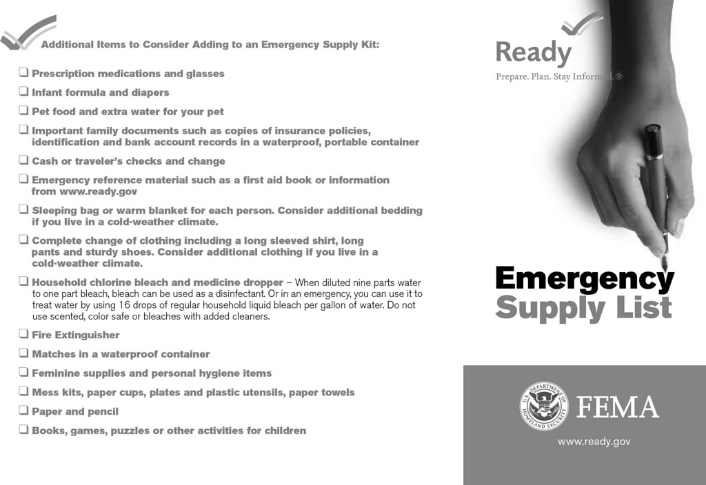
after Cascadia earthquake, outside help may be 2-3 weeks away - Disaster Kits should contain items needed
for basic survival such as water, food, and first aid essentials. - For any items with batteries, periodically recharge or replace.
- Store in large, sturdy container or smaller portable ones
-- generally, in dry, cool, dark (if possible) areas,
likely to be accessible after an earthquake, e.g.,
garage (w/ concrete floor); outdoor shed;
closets-- could you pry open jammed doors?
in tsunami zone, nearby rental storage unit uphill from you?
- 2-Week supply of non-perishable food
(dried fruit, canned tuna fish, peanut butter, etc.) - Can opener
- Paper plates, plastic cups and utensils, paper towels
- Moist towelettes, garbage bags
and plastic ties for personal sanitation - Water -- at least a gallon per person,
per day for drinking and hygiene
Purification (Flood: Sanitation) - First aid kit; Terri's List
- Prescription medication and glasses
- Sleeping bag or warm blanket for everyone in your family
- Change of clothes to last for at least 3 days,
including sturdy shoes; consider the weather where you live - Matches in a waterproof container
- Toothbrush, toothpaste, soap and other personal items
- Feminine hygiene supplies
- Fire extinguisher
- Wrench or pliers to turn off utilities
-- non-sparking (i.e., non-ferrous) for gas - Other suggestions: headlamps;
cable to charge devices from car battery / cigarette lighter;
...
- Household chlorine bleach (unscented)
- Dust mask (N95), and plastic sheeting and duct tape,
to help filter contaminated air - Battery-powered or hand-cranked NOAA radio
and extra batteries -- several: 1 for home, 1 to go?
some walkie-talkies (FRS) may include NOAA channels;
Be Informed: NOAA, FRS - Cell phone with charger, external battery pack or solar charger
- Whistle to signal for help
- Local maps
- Cash in small bills (ATMs may be empty or not work)
- Emergency reference material such as first aid book
or information from ready.gov - Important family documents such as copies of ID,
insurance policies, and bank records
in a waterproof, portable container - Infant formula and diapers
- Paper and pencil
- Books, games or puzzles
- Pet food, other supplies, and extra water for your pet
- Share resources among neighbors (i.e., MYN),
e.g., larger first aid kits; tools;
campstoves / outdoor grills;
generator & fuel (safely stored);
share woodstove / fireplace (if no heat);
...
 References
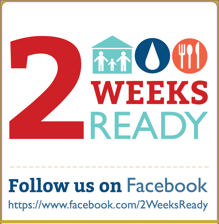
- Oregon Office of Emergency Management (OEM): 2 Weeks Ready, Facebook
- brochures: Business; Children; Communications; Community; First Aid; Food (Eng.; Span.);
Neighborhood Pets (Eng.; Span.); Seniors (Eng.; Span.); Shelter; Water (Eng.; Span.) - videos: 2 Weeks Ready Overview; First Aid; Food; Pets and Livestock; Secure Your Home;
Shelter; Water; Youth - earthquake resources: Safety Information; Living on Shaky Ground (Eng.; Span.)
- Jackson County: Preparedness Kit List home & car;
Preparedness Calendar: disaster supplies and preparedness activities over 12 months - ready.gov: List of Items for Preparing a Kit; Get Tech Ready; Preparedness Calendar
- redcross.org: How to Prepare for Emergencies; Emergency Preparedness Kit;
Resource Guide; Food and Water in an Emergency .pdf; w/ FEMA - CDC: Creating and Storing an Emergency Water Supply
- The Best Power Outage Tools and Supplies
Portable generator; Surge protector
Uninterruptible power supply;
USB battery pack for phones & tablets, laptops;
Portable power station; Power inverter; LED lantern
Flashlight; Headlamp; Board game; NYT; 2/21/2023 - How to Pick a Solar Panel and Battery Backup System NYT; 12/21/2022
- Your First Aid Kit May Be Expired LH; 7/15/2022
- The Best Emergency Gear to Keep at Home Wired; 6/12/2022
- The Best Portable Generators NYT; 3/24/2022
- How to Stock an Apocalypse Pantry LH; 5/3/2022
- The Best Power Outage Tools and Supplies NYT; 2/17/2022
- The Best Emergency Gear to Keep at Home
flashlight; lantern; water purifier; propane camp stove;
spare mattress; portable charger and radio; warm clothes;
your coffee fix; bathroom needs; generator (in certain circumstances);
other essentials; Wired; 2/16/2022 - Generator buying guide: What you need to know
generator safety, the different types of generators; CNet; 2/10/2022 - The Best Emergency Preparedness Supplies reviews; 12 essentials; NYT; 10/7/2020
- Earthquake preparedness: Where to store your emergency supplies 1/10/2019
- OLLI Course: Be Safer on the Internet: Backups: Disaster
Other Useful Kits: Go, Car, Under-the-Bed, Financial
- Go Bag -- see section: 3. Evacuation Planning
- Emergency Kit for your Car
- Under-the-Bed Kit -- see section: 8. Earthquake
- Emergency Financial First Aid Kit
Disaster Preparedness: 6. Prepare for Wildfire
Disaster Preparedness: 6. Prepare for Wildfire
Before the Fire | References: General, Almeda
Ashland Residents Are Highly Encouraged To Create Defensible Space
To Reduce The Risk Of Wildfire Around Their Homes And Neighborhoods.
- I Googled 'how to start a wildfire'...
- What do you call the Robin Williams movie about a hot California summer?...

 Before the Fire Checklist
- Planning & Evacuation topics covered in earlier sections:
#2. Evacuation Process: Ready, Set, Go;
#3. Evacuation Planning;
#4. Family Disaster Planning - medfordoregon.gov/beprepared; ashland.or.us/evacuate
- video: Wildfire Ember Highlights 4:17
- video: Disaster Preparedness Training -- Wildfire 1:36
 3 Zones of Concern near your home
- Immediate: 0-5': structure itself, attachments, landscaping
structure: rated roof materials; ≤1/8" wire mesh over vents/soffits;
non-flammable siding;
attachments: ignition-resistant deck/porch; enclosed decks;
non-wood fence attachment
landscape: no flammable plants; no bark mulch;
no stacked firewood or other material - Keep roof and gutters free of all leaves, needles, and debris throughout fire season
- Check that all vents in foundation and eaves are screened with 1/8 inch
or finer metal mesh screening and baffled vents to prevent ember intrusion - Maintain three to five foot buffer area around foundation with
no combustible plants or material in contact with siding
(NO BARK MULCH) and clean up all leaf and needle debris - Ensure area under deck is clean of combustible debris and
no combustibles (firewood, lumber, fuel) are stored underneath - Screen off or enclose open areas under decks and overhangs
with 1/8 inch metal mesh screening to prevent ember intrusion - Intermediate: 5'-30': reduce fire intensity, contact, paths
-- remove bark mulch and flammable vegetation;
replace flammable privacy screening/fencing - Use only Firewise plants within 30 feet of your home; fireadaptedashland.org/firewiseplants
- Keep tree limbs pruned at least 10' from house, and 10' from chimney
-- if conflicts with Ashland Tree Commission, contact ashlandfirewise.org - Limb up lower branches 5-6 feet on trees within 30 feet of your home
- Extended: 30'-100': extended landscaping
-- reduce surface fuel, canopy density, ladder fuels - Store firewood 30 feet away or in an ember proof storage shed
- Keep dry grass and weeds mowed to four inches or less throughout fire season: ashland.or.us/weedabatement
- Driveway accessible, with home address clearly posted and visible from the street
 References / Resources
- subsection: Almeda
- OLLI Living with Fire at Home and in the Landscape
co-taught by Charisse Sydoriak and Mary Kwart; class reference materials; Spring 2021 - Ashland: "In July of 2020, the City of Ashland mailed every homeowner in Ashland
a postcard with an access code to view your property's wildfire risk score,
and to provide information on how to reduce your wildfire risk."
-- fireadaptedashland.org: more info, replacing postcard/code - Most assessments like that are curbside/general, e.g., Ashland; other areas
- To get a detailed, personalized assessment:
541-552-2231; ashlandfirewise.org - To volunteer: Wildfire Risk Assessment Program (WRAP): ashland.or.us/wrap;
10. Get Involved: WRAP - Fire Prevention and Safety; Wildfire Preparedness
- ashland.or.us/fireseason; fireadaptedashland.org ;
Wildfire Safety Campaign: fireadaptedashland.org/wildfireprep - ashland.or.us/weedabatement; ashland.or.us/prohibitedplants
- ashlandwatershed.org Ashland Forest Resiliency Project
- smokewiseashland.org
- Did we learn anything from the Almeda Fire? Plenty. AN; 9/11/2023
- Almeda Fire-fight memories still burn bright 3 years after fire put out AN; 9/8/2023
- City of Ashland Wildfire Safety Campaign Launching April 2021
Ashland residents are being called to prepare for the upcoming wildfire season through a four-month campaign
developed by Ashland Fire & Rescue and the Wildfire Safety Commission.
April: Harden your Home! April will focus on educating residents to harden their structures to embers.
Embers account for nearly 90% of ignitions during a wildfire event. Preparing your roof, gutters, decks, and
siding to resist ignition by embers can prevent wildfire from burning your home. The work done to harden your
home can stop the cycle of home-to-home wildfire spread.
May: Firewise your Landscape! May will focus on educating residents to prepare their yards and
landscaping for wildfire. Properly managed home landscaping can stop the spread of flames before they reach
your home and resist ignition by embers - the key is to keep your landscaping lean, clean and green.
Ashland residents can bring their flammable green debris to Green Debris Drop Off Day, Sunday May 2nd.
Information about Drop Off Day can be found at: ashland.or.us/greendebris
June: Be Ready to Evacuate! June will focus on educating residents to understand the
three levels of evacuation: Be Ready (Level 1), Be Set (Level 2), Go! (Level 3). It is important that residents
be ready to evacuate at a moment’s notice from your home or your workplace by creating an evacuation kit
for every member of your household.
July: Be Smokewise! July will focus on helping residents understand what they can do to prepare
for the possibility of wildfire smoke. There are several actions residents can take to ensure good air quality in their homes.
Smokewiseashland.org is a one-stop-shop for residents and businesses to learn how to create good air quality inside,
to find up-to-date smoke information, and understand how smoke may impact your health.
Details about the Wildfire Preparedness Campaign can be found at fireadaptedashland.org/wildfireprep.
The website includes easy to follow checklists for each month. Information about the campaign will also
be on display at local stores and the Tuesday Farmer’s Market in Ashland. - Jackson County: Wildfires & Smoke; Home Ignition Zone: 5 Step Assessment
- District 5 (assessments):541-535-4222 -- or contact your local fire department
- Medford: Wildfire Safety; weather.gov/mfr/
- JC Official Damage Assessment: interactive map
- Defensible Space Handout (from ODF)
- ODF Public User Restrictions during Fire Season (chart)
- Oregon Wildfire Recovery: wildfire.oregon.gov
- fireweatheravalanche.org: Wildfires, Forest Fires, Lightning Strikes
- ODF (referral or assessment): 541-664-3328
- Oregon Department of Forestry (ODF): Fire Tracker; SW Oregon Fire (swofire.com)
- FB:Wildfire Information; It's Time to Create Defensible Space Around Your Home
- section: Emergency vs. Disaster: Wildfires
- National Fire Protection Agency (nfpa.org; firewise.org);
video: Your Home and Wildfire. Choices that can make a difference 3:56 - National Interagency Fire Center
- Fire and Smoke Map: fire.airnow.gov;
Wildfire maps: inciweb.nwcg.gov; NOAA:Fire Weather - Risk Factor of Flood & Fire by zip code
- ALERTWildfire University of Oregon Hazards Lab (ohaz.uoregon.edu)
- Oregon Wildfire Risk Explorer
- A Crowdsourced Wildfire App Tracks All of California's Blazes
Watch Duty is already a lifeline for the state’s residents.
Its reach could soon extend to more disasters and regions.
Wired; 8/17/2022 - Here Are the Wildfire Risks to Homes Across the Lower 48 States NYT; 5/16/2022
- These Are the Tools You Need in Case of an Earthquake, Flood, or Wildfire LH; 12/23/2021
- Wildfire Terms Defined: What It Means When a Blaze Is 30 Percent Contained NYT; 8/19/2021
- How to Help Prepare Your Home for the Threat of Wildfires NYT; 6/16/2021
- Guide offers fire preparation tips kswild.org/forest-fire-toolkit; MailTribune; 3/25/2021
- Local lakes at historically low levels Mail Tribune; 3/16/2021
- Spring Wildfire Campaign Tidings; 2/24/2021
Almeda
- Get rOLLIng to avoid CERTain disaster Terri's Almeda presentation; 3/31/2021
- OLLI Disaster Class Spurred by Alameda Fire (.pdf); 1/11/2021
- Terri Stewart is Program Coordinator for the City of Ashland Fire & Rescue's
Community Emergency Response Team (CERT):ashlandcert.org. - She coordinates citizen support and preparedness efforts in Ashland through training courses,
and community outreach programs such as Map Your Neighborhood (MYN):ashland.or.us/myn - Since accepting the position in 2011, she has obtained $91,000 in grants to enhance citizen preparedness.
- Terri is an adjunct at Southern Oregon University, and has taught OLLI courses about First Aid and preparedness.
- Ashland: Almeda Fire
- Ashland City Council Wildfire Forum (3/10/2021): video: 2:02:32; forum FAQ .pdf
- Almeda After Action Review (AAR): Lessons Learned; .pdf; 30 pp;
(based on: Almeda Fire Public Engagement Survey Presentation
Council Study Session; .pdf; 333 pp; 11/30/2020) - Jackson County Fire Incidents After Action Report .pdf; video: 8:47; JC; 6/2/2021
- Jackson County EOC reports
- Jackson County Live evacuation Map
- Almeda, Obenchain Evacuation Maps .pdf: 9/2020
- roguevalleyrebuilds.org:
Recovery: Housing, Financial, Cleanup, Donate
Rebuilding: Cleanup and debris removal; Planning and permitting; Construction
Resources: Organizations, Government Agencies, Utilities - roguevalley.recovers.org:
Get assistance: connect with the goods and services you need.
Send supplies: connect with people who need them.
Lend a hand: connect with people who need your help. - Report details what went right, wrong during Almeda and Obenchain fires MailTrib; 6/5/2021
- 2020 Hindsight: Preventing another Almeda, Gallery: 2020 fires Mail Tribune; 12/26/2020
- Rebuilding After A Wildfire? Most States Don't Require Fire-Resistant Materials
Ashland, Medford building codes; quotes from AFR's Ralph Sartain; NPR; 11/25/2020 - Ashland water came close to hitting bottom this year
sources: Reeder Reservoir, Talent Irrigation District (TID),
Talent-Ashland-Phoenix (TAP) intertie; MailTribune; 11/2/2020 - 12 hours inside Oregon's Almeda Fire
destructive wildfire exposes state’s need for more firefighting resources; WaPo; 10/20/2020 - Mapping the Almeda Drive Fire Jackson County uses ARCGIS; 10/9/2020
- We WILL Rise Again From the Ashes sneakpre.com; Vol 30, No. 12; p44; 10/1/2020
- 'Too much heat, too much wind, not enough water, not enough resources' MailTribune; 9/23/2020
- An American Dream, Scorched in Oregon Almeda; NYT; 9/29/2020
- video: How an Oregon Wildfire Became One of the Most Destructive Almeda; NYT; 9/20/2020
Disaster Preparedness: 7. When Smoke is in the Air
Disaster Preparedness: 7. When Smoke is in the Air
Air Quality Index (AQI) | Who's Most at Risk? |
How Do I Protect Myself? | Watch for Symptoms
Wildfires Spread Rapidly And Can Quickly Change Air Quality.
You Need To Be Ready To Cope With Smoke.
 Air Quality Index (AQI); Smoke
- measurements between sites may vary depending on different factors:
real-time vs. time average; outdoor vs. indoor sensor location; particle size; corrections - smokewiseashland.org -- provided to OR DEQ, airnow.gov;
"NowCast" AQI calculation; sensor outside at Fire Station 1 - purpleair.com:
Map Data Layer:US EPA 2.5PM AQI; Conversion:US EPA;
some variation (vs. smokewiseashland.org) due to correction factor,
update & averaging times; sensors at multiple locations -- incl. Ashland Fire Station 1;
How do PurpleAir sensors compare to regulatory particulate matter sensors? - Jackson County: Wildfires & Smoke
- Oregon DEQ
- oregonsmoke.org
 airnow.gov: AQI; fire.airnow.gov: fires and smoky areas
- NOAA: smoke
- ventusky.com: Wind, Rain and Temperature Maps
- NWS: Air Quality, Heat / UV, alerts
- Track Wildfires in the West: AQI, Smoke NYT; 2022
- The Air Quality Index Explained: What It Means and How to Stay Safe NYT; 6/17/2021
 Who's Most at Risk?
- Children, older adults, pregnant or nursing mothers, and those
with pre-existing respiratory ailments should take preventative actions
when the AQI level or symptoms dictate. - smokewiseashland.org
How Do I Protect Myself?
- Limit your exposure to smoke. Close windows and doors.
- Follow recommended AQI guidelines for outdoor activities.
- Avoid anything that increases indoor pollution
like candles or vacuuming. - Run an air conditioner or air cleaner with HEPA
or MERV 13 or higher rated filter. - Install air purification system, e.g.,
Whole Home LED In-Duct Air Purifier  Fine particles can be filtered with an N95
or N100 face mask. Ensure a tight fit!- Follow the advice of your doctor or
healthcare provider. Call if symptoms worsen. - Consider leaving the area if you are sensitive
and smoke is an ongoing problem. - The Best Air Purifier NYT; 1/26/2022
- The City of Ashland’s Air Purifier Pilot Program
$85,000 grant from OR DEQ to give away 500 HEPA air
purifiers to most smoke-vulnerable residents; 9/17/2020
 Watch for Symptoms
- Smoke can make respiratory disease symptoms worse
and trigger asthma attacks. - Even otherwise healthy people can experience coughing,
shortness of breath, wheezing, and chest tightness. - Contact a healthcare provider for further advice
or call 911 in an emergency.
Disaster Preparedness: 8. Earthquake
Disaster Preparedness: 8. Earthquake
Before the Earthquake: Understand the Risk; Get Prepared |
During an Earthquake |
After the Earthquake: Turning Off Your Utilities? |
References: General | Tsunamis
- The good news about earthquakes?...
- Q: What do you call an earthquake during a production of Hamlet?...
- Q: What do cows produce during an earthquake?...
- The 911 operator didn’t take my report of an earthquake seriously...
 Before the Earthquake
Understand the Risk
- Cascadia Subduction Zone (CSZ): megathrust fault
- 70-100 mi. offshore between Cape Mendocino (CA) & Vancouver Island (BC)
- expect 8-9+M* event, lasting 3-5 minutes
- involving a section or entire 1130 km (700 mi) fault length
- occuring every 250-350 years, on average
- causing: tsunamis; landslides; damage to homes, infrastructure,...
- For some perspective, CSZ estimates compared to the Loma Prieta quake (10/17/1989, near Santa Cruz CA):
Cascadia Subduction Zone (CSZ) magnitude: M8-M9 -- 10x - 100x stronger than Loma Prieta (M6.9)
CSZ duration: 3-5 minutes -- 12x - 20x longer than Loma Prieta (15 seconds) - *M = Magnitude (Richter, etc.); MMI = Modified Mercalli Intensity;
both are logarithmic; comparison: M vs. MMI 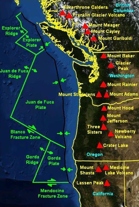 Scientists began piecing together evidence for CSZ in the mid-1980s
- Last occurrence: Jan. 26, 1700, ~9pm; ~M9; entire length
- Japan: 'orphan' tsunami recorded -- precise date
- Cowichan (BC): shaking so violent that they could not stand,
so prolonged that it made them sick; collapsed houses;
landslides; tsunami survivors lived 75+ feet above waterline - Hoh (WA): Thunderbird & Whale fight uprooted trees, shook mountains
- Tillamook (OR): changed what they hunted, what they ate,
how their houses were built, where they lived - Yurok (CA): jumping dance did not prevent tsunami -- ritual implies previous events
- Geological record: 'ghost' forests, tree rings; sea slides / salt marshes
-- past quake frequency, intensity - In 2010, OSU geologists predicted:
- a 37% chance of a CSZ M8.2+ event within 50 years, and
- a 10-15% chance that the entire Cascadia Subduction Zone
will rupture with an M9+ event within the same time frame. 
 A Cascadia event occurs every 250-350 years on average.
- It's now been 320+ years since 1700,
with many more people and structures. - We're "due" -- with greater likelihood than 2010
estimates, and much more devastation than 1700.
[on right: shaking intensity; damage potential] - Besides CSZ, other regional earthquake faults:
e.g., 1993 Klamath Falls earthquakes M6 - The Really Big One New Yorker; 7/13/2015;
"'The Really Big One' is a story about [an earthquake and] a tsunami, that is destined
to hit the Pacific Northwest, and we don’t know when. The tools of journalism employed
there are just absolutely, absolutely incredible.... It is one of the greatest pieces of writing
I’ve ever read." ~Ta-Nehisi Coates (in Ezra Klein interview; NYT) - video: Toast, tsunamis and the really big one; 14:13
Chris Goldfinger, OSU; history of Cascadia; infrastructure damage; TEDx; 7/5/2016 - video: iris.edu: Pacific Northwest Earthquakes: 3 Types;
8:05 Incorporated Research Institutions for Seismology (IRIS); 7/19/2015 - video: Cascadia 21:09;
James Roddy, DOGAMI: Oregon Dept. of Geology and Mineral Industries; 12/1/2011
Get Prepared
- video: Disaster Preparedness Training -- Earthquakes 1:40; CERT
- Be sure your phone can receive Wireless Emergency Alerts;
optional: install a ShakeAlert app for additional info, e.g., MyShake - Building survival depends on various factors: type & length of quake;
construction type (wood vs. masonry); anchored to foundation?
density of soil (rock vs. fill); construction / retrofitting publications,
e.g., FEMA: Earthquake Building Science - video: Earthquakes and Unreinforced Masonry (URM) Buildings
Portland Bureau of Emer. Mgmt.; 2016 
 Check with insurance agent about earthquake coverage.
- Securely anchor gas appliances, water heaters, heavy furniture and
light fixtures, wall décor, and fragile shelving contents (breakables);
install cabinet latches? 
 Locate utility shut-off valves and know how to turn them off.
- Know where your fire extinguishers are, and check their status.
- If living at or visiting the OR coast, know about evacuation
routes: OR Tsunami Evacuation Maps - Bigger quakes may affect larger area, cause landslides, damage bridges -- especially at coast;
we may be isolated in our neighborhoods for 2 weeks, probably longer, until outside help can arrive. - Store a #5. 2 Weeks Ready: Disaster Supply Kit (in a secure location)
and have a #3. Family Communication Plan.  Organize or attend a Map Your Neighborhood (MYN) meeting;
neighbors can learn how to support each other more effectively.- Prepare an Under-the-Bed Kit [example on right]
to safeguard against the most common injuries to head, hands, and feet --
there will be broken glass; power may be out; it may be dark. - Include a hard hat, leather gloves, and socks & close-toed shoes,
eyewear (reading and/or safety), flashlight w/ batteries, whistle,
non-ferrous wrench (pictured: 4-in-1 tool for gas, water, dig, pry),
MYN booklet, NOAA radio, tote bag, pet leash, ...;
for additional people, add items or separate kits.
During an Earthquake
- Pay attention to any early warnings: did you feel initial P-wave?
- Receive notification? shakealert.org; video: 4:38;
iris.edu: ShakeAlert; Be Informed: ShakeAlert - Put on your hard hat if under-the-bed kit is handy.
- DROP! COVER! & HOLD ON!
-
 It may be difficult/unsafe to stand or run.
 - If you are inside, do not go outside.
Interior door frames may collapse.
Shelter under a sturdy table or desk, or near a wall
away from glass and objects that can fall on you. - If you're in an unreinforced masonry building,
e.g., Ashland City Hall, old school, etc., and you have enough warning time
to exit safely, an open area (field, park) may be preferable. - If on unstable bridge, e.g., Medford viaduct, get off quickly or ...
- If you are outside, check your surroundings
-- stay away from obvious hazards such as older buildings, bridges and electrical wires, trees, etc. - If in a car, pull over to an area away from buildings, bridges, trees and powerlines.
 After the Earthquake: Proceed with Caution
- Protect your head, hands, feet from broken glass, falling objects, etc.
(under-the-bed kit). - Be aware of aftershocks. Assess your situation.
- After shaking stops, if in a tsunami zone, e.g., on OR coast, go to higher ground:
evacuate (probably on foot) within 15+ minutes to 100'+ above sea level. - Determine if your environment is safe to stay in.
Turn off utilities if necessary.  Use your fire extinguisher on any small fires, e.g., typical household size for wastebasket-scale fires.
- Types of fires & extinguishers: "ABC" for typical household use
- Some fire extinguishers are rechargeable
-- check label for recommended maintenance / replacement - video: 2:01; PASS: Pull pin, Aim nozzle, Squeeze handle, Sweep nozzle at base of fire
- How to Know When It's Time to Buy a New Fire Extinguisher
5-15 years? check pressure gauge; LH; 2/21/2021 - Locate your MYN booklet (from your under-the-bed kit),
along with updated neighborhood contact & resource summaries.  Calmly start to follow the 9 MYN Steps to coordinate with your neighbors.
- Gather Critical Information. Tune to 1700 AM or NOAA stations
-- see section 1. Alerts & Communication - Listen to directions from officials including emergency responders.
- Be grateful that you had prepared to shelter-in-place
-- section 4. Family Disaster Planning
and have adequate supplies for several weeks -- section: 5. 2 Weeks Ready

 Turning Off Your Utilities?
- Only do so if leak or breakage is suspected
as it may take weeks to months
for utility providers to restore services. - Gas: Do you smell, hear or see a leak?
Using a non-sparking, non-ferrous wrench
(not iron or steel), turn the valve perpendicular to pipe flow. - Install a "California Valve" -- an earthquake-sensitive gas automatic shut-off valve?
- Water: Turn valve to closed position on the home side. Valve is similar to gas valve.
Besides controlling leaks, it could preserve clean water for later use.  Circuit Breakers: Turn off each individually before
turning the main off, to minimize risk of electric shock;
reverse process for turning back on.- videos: Turn Off Electricity; Shut off Gas
- How to Stay Warm When the Power Is Out LH; 2/16/2021
References
- section: Emergency vs. Disaster: Earthquakes
- Ashland Emergency Preparedness
Evacuation Zone; Evacuation Levels; Get Ready; Wildfire Info; Fire Adapted Ashland;
Chamber of Commerce Preparedness Toolkit; Smokewise Ashland; Nat. Weather Service - Jackson County Emergency Management
Citizen Alert; Wildfire & Smoke; Get Ready Rogue; Jackson County Plans;
News & Information; Resources; Natural Hazard Mitigation Plan - Rogue Valley Emergency Management (RVEM): Jackson & Josephine Counties
Citizen Alert; Incident Info; Get Ready Rogue: Know Your Hazards; Preparedness Fundamentals;
Special Considerations; Kit Types; Resources; Preparedness Calendar; Prep U -

"Earthquake Survival Kit" by Global X
is licensed under CC BY 2.0Wikipedia: Cascadia subduction zone; 1700 Cascadia Earthquake;
Earthquake-resistant construction - Seven Steps to Earthquake Safety
Prepare (Before) 1. Secure your space; 2. Plan to be safe;
3. Organize disaster supplies; 4. Minimize financial hardship
Survive and Recover (During/After) 5. Drop, Cover, and Hold On;
6. Improve safety; 7. Reconnect and Restore; Earthquake Country Alliance - Big quake of 1700 RV Times; 2/8/2023
- What's your earthquake risk? Use this map to find out CNN; 5/23/2023
- Life Kit: Preparing for an earthquake NPR; 4/22/2023
- How Fiber Optic Cables Could Warn You of an Earthquake
by firing lasers through underground fibers, scientists can detect seismic waves and perhaps improve alerts -- giving people precious time to prepare; Wired; 2/10/2023 - It's been 323 years since the last Cascadia Subduction Zone earthquake.
How prepared are you for the ‘Big One?’ Oreg; 1/27/2023 - Magnitude 6.4 Earthquake near Ferndale, California reported via ShakeAlert! USGS; 12/20/2022
- 6.4-Magnitude Earthquake Shakes Northern California
the quake struck southwest of Eureka at about 2:30 a.m., leaving at least two people dead
and knocking out power for tens of thousands of customers in Humboldt County; NYT; 12/20/2022 - Gravity signals could detect earthquakes at the speed of light faster and more reliably; science.org; 5/11/2022
- When the Big One Hits Portland, Cargo Bikers Will Save You Wired; 9/13/2022
- These Are the Tools You Need in Case of an Earthquake, Flood, or Wildfire LH; 12/23/2021
- 50 earthquakes hit off the Oregon coast, but scientists say they're no great shakes
Blanco Transform Fault Zone; NPR; 12/8/2021 - Gearing up for the big one: The state is working to fortify several highway bridges
in Southern Oregon considered at risk from a Cascadia Subduction Zone earthquake MT; 11/2/2021 - The Long-Lost Tale of an 18th-Century Tsunami, as Told by Trees Wired; 9/23/2021
- The Top 10 Tools for Earthquake Preparedness
Water container; Gas shut-off tool; Fire extinguisher; Emergency radio; USB battery pack;
Headlamp; Lantern; Extra batteries; First aid; Duct tape; NYT; 7/7/2021 - Earthquake Awareness and Preparation Summary .pdf; Eric Dittmer & Harry Smedes, SOU; 3/2021
- video: Houses Tested On Earthquake Simulation Tables
From Around The World 7:06; Bay Area Seismic Retrofit TV; 8/15/2020 - How does the Rogue Valley fit into the larger tectonic picture?
Karen Grove: landscapes-revealed.net; 5/10/2020 - A big earthquake in the US Pacific Northwest? earthsky.org; 8/5/2019
- video: Oregon Field Guide (OFG): Unprepared YouTube; 56:15; Chris Goldfinger; 4/26/2017;
OFG spent a year-and-a-half probing into the state of Oregon’s preparedness, and found
that when it comes to bridges, schools, hospitals, building codes and energy infrastructure,
Oregon lags far behind many quake-prone regions of the country. - Available also: OFG: Unprepared SOPBS; Season 27; Episode 2701; Aired: 11/26/15
- video: Strain build-up and release in earthquakes at subduction zones 1:15; IRIS; 7/18/2016
- After The Big One science fiction saga about surviving the coming,
most devastating mega-quake in US History, headed for Portland; 3/3/2016 - video: Great Earthquakes of the Pacific Northwest 1:04:00; Nick Zentner; Central WA Univ.; 2/16/2016
- The Great Quake and the Great Drowning
Indigenous people's terrifying tsunami stories are a history and a warning; Slate; 9/15/2015 - The Really Big One Cascadia earthquake will destroy a sizable portion of the coastal Northwest.
The question is when; New Yorker; 7/13/2015 - The orphan tsunami of 1700 -- Japanese clues to a parent earthquake in North America UW; 2015
- video: Earthquake Liquefaction Example 1:13; Illinois Geological Survey; 1/31/2014
- Living With Earthquakes In The Pacific Northwest: A Survivor's Guide
Robert S. Yeats; OR State; 3rd edition; free to download; 2013? - A Consumer's Guide to Earthquake Insurance
.pdf; National Association of Insurance Commissioners (NAIC); 10/11/2011 - Odds are about 1-in-3 that mega-earthquake will hit Pacific Northwest in next 50 years, scientists say
OSU report; ScienceDaily; 5/25/2010 - Dating the 1700 Cascadia Earthquake: Great Coastal Earthquakes in Native Stories
Seismological Research Letters Volume 76, Number 2, March/April 2005 - Japanese shipwreck adds to evidence of great Cascadia earthquake in 1700 UW; 10/31/2003
Tsunamis
- section: Emergency vs. Disaster: Tsunamis
- The Tsunami Could Kill Thousands. Can They Build An Escape?
evacuation towers? includes inundation zone maps in CA, OR and WA; NYT; 2/7/2022 - Everything You Need to Know to Survive a Tsunami
Advanced preparation for a tsunami;
Recognize the signs of an impending tsunami;
A tsunami is on its way -- what now?;
After the tsunami; LH; 1/12/2022 - The Long-Lost Tale of an 18th-Century Tsunami, as Told by Trees Wired; 9/23/2021
- Oregon's Tsunami Risk: Between the Devil and the Deep Blue Sea
building in tsunami zones; New Yorker; 7/1/2019 - Living on Shaky Ground: How to survive earthquakes and tsunamis in Oregon .pdf; 2018
- The Great Quake and the Great Drowning
Indigenous people's terrifying tsunami stories are a history and a warning; Slate; 9/15/2015 - The orphan tsunami of 1700 -- Japanese clues to a parent earthquake in North America UW; 2015
Disaster Preparedness: 9. Flood
Disaster Preparedness: 9. Flood
The Basics | Sanitation | Landslides | Refs
The Basics
- Rogue Valley rivers, creeks and tributaries are prone to flooding.
- Ashland's CERT program was started in 1999
after a severe flood on New Year's Day 1997 [image: below right],
caused not by dam failure, but by unseasonable rain & warm weather
melting the snowpack, amplified by blockages from downed trees and
other debris; water and sewer were out for ~9 days  videos: Rogue Valley Flood 1997 2:35 Ashland Plaza @ 0:45;
Disaster Preparedness Training - Floods 2:50- The tsunami-looking sign [top right] is to warn of flash floods if Hosler Dam fails;
like a tsunami, immediate evacuation from the inundation zone to higher ground
is recommended after a siren or strong earthquake. - Educate yourself regarding the danger
and purchase flood insurance whether you rent or own. - Localized flooding and pooling occurs frequently during rain events.
Infrastructure impacts include: closing roads / bridges, water treatment plants.
Consider educating yourself regarding where to purchase and how to fill sandbags. - Be aware of flash flooding. Six inches of water can sweep you off your feet.
Two feet of water is enough to float a vehicle. Water conceals other hazards as well. - Purchase a hand-crank NOAA radio,
or use walkie-talkie with NOAA channels; see Be Informed: NOAA - Ashland: ashland.or.us/flood: Ordinances; Protection;
Recent Events; Causes; Insurance; Safety Tips; Contacts - Hosler Dam Early Warning System .pdf; includes flood zone map; section: 1. Alerts: Sirens: Hosler Dam
- video: Ashland tests Hosler Dam flood warning sirens 0:40
Flood Insurance; Special Flood Hazard Area; Preparing for a Flood; Maps- Rogue Valley Floods: 1861, 1890, 1892, 1924, 1945, 1953, 1962, 1974, 1997
(original Mail Tribune articles missing) - Flood Maps: Oregon, FEMA
- section: Emergency vs. Disaster: Floods
- A look back at Ashland’s New Year’s Day Flood
just over 25 years ago, Ashland awoke to a new year and a rampaging creek; AN; 4/3/2022 - These Are the Tools You Need in Case of an Earthquake, Flood, or Wildfire LH; 12/23/2021
- This simple iPhone toggle can help protect your home from break-ins and floods
Settings > Accessibility > Sound Recognition: Alarms, Animals, Household, People;
not a replacement for home monitoring or smart alarm; MW; 11/23/2021 - How to Escape Your Car in a Flood NYT; 9/29/2021
- How to Stay Safe During a Flash Flood NYT; 9/13/2021
- How to Prepare for (And Survive) a Flood LH; 3/4/2021
 Sanitation
- Public drinking water may be impacted during floods and
related events. It is critical to listen to emergency health
updates for water use and contamination. - You may need to filter and/or purify water before drinking,
e.g., clear water: boil for 3 minutes;
or 8 drops unscented household bleach/gallon of water - Other options: gravity & pump filters,
and ultraviolet light purifiers, e.g., REI water purifiers - CDC: Keep Food and Water Safe After a Disaster or Emergency;
Creating and Storing an Emergency Water Supply - FEMA and Red Cross: Food and Water in an Emergency .pdf
- FDA: Food and Water Safety During Power Outages and Floods;
commercially bottled water should have an unlimited shelf-life
when stored in original sealed containers, in a dark, cool location. - One student suggestion for large tank storage: Grady Barrels
- A Sewer Catastrophe Companion: Dry Toilets for Wet Disasters .pdf; 2012
 Landslides
- Oregon has steep slopes and loose soil that is highly susceptible
to landslides. Though landslides most frequently occur after wildfires,
they can occur during and after long periods of heavy rain. - The Oregon Department of Geology and Mineral Industries
(DOGAMI) has compiled information to help identify and
reduce landslide hazards around the home.
If a landslide warning is issued, be prepared to evacuate. - section: Emergency vs. Disaster: Landslides
- videos: Old Highway 99 mudslide 1:05;
Disaster Preparedness Training - Landslides 5:37 - videos: Landslide and Debris Flows USGS
- Five Years Later: The Oso (SR 530) Landslide in Washington
2:18; computer simulation; 3/20/2019
References
- Ashland Emergency Preparedness
Evacuation Zone; Evacuation Levels; Get Ready; Wildfire Info; Fire Adapted Ashland;
Chamber of Commerce Preparedness Toolkit; Smokewise Ashland; Nat. Weather Service - Jackson County Emergency Management
Citizen Alert; Wildfire & Smoke; Get Ready Rogue; Jackson County Plans;
News & Information; Resources; Natural Hazard Mitigation Plan - Rogue Valley Emergency Management (RVEM): Jackson & Josephine Counties
Citizen Alert; Incident Info; Get Ready Rogue: Know Your Hazards; Preparedness Fundamentals;
Special Considerations; Kit Types; Resources; Preparedness Calendar; Prep U
Disaster Preparedness: 10. Get Involved
Disaster Preparedness: 10. Get Involved
Map Your Neighborhood (MYN) |
Community Emergency Response Team (CERT) |
Wildfire Risk Assessment Program (WRAP) |
Other Training and Volunteer Opportunities
 Map Your Neighborhood (MYN)
- Before a disaster: a neighorhood group of ~18-24 households meets with a MYN Facilitator
to learn about preparedness and 9 response steps,
and to share information with each other -- contacts, needs, skills, resources - After a disaster: neighbors follow 9 response steps and assist each other.
- The MYN program continues to provide community outreach through the nine steps to preparedness.
Community members have the opportunity to partake in the free program
adopted and administered locally through the CERT program. - MYN encompasses small neighborhood disaster planning and response, incorporating the
individual neighbors' skills and expertise and equipment inventory into planning for a catastrophic event. - The MYN program promotes readiness and action among neighbors through the response planning process.
Neighbors taking advantage of the planning program identify individual needs of families with
small children, pets, elderly, and infirm to formulate plans regarding appropriate actions
as necessary to respond to these neighbors in a disaster. - Ashland/Talent: to learn more or sign up: ashland.or.us/myn
- For other areas, check with your Fire Department.
- Brochure; Overview of Program (slides)
- Workbook .pdf (ignore non-CERT contact info)
- 9 Steps (slides): All Hazards; Wildland Fire
- MYN Crossword [below right]
- CERT team members alerted MYN neighbors in Talent Mail Tribune; 11/2/2020
 Overview of a MYN Meeting and the 9-Step Process
- A Neighborhood Coordinator -- HOA leader or any motivated resident,
gauges interest of neighbors in attending a MYN meeting, and suggests possible dates. - Coordinator contacts CERT: ashland.or.us/myn
- CERT helps define boundaries of "the neighborhood", usually ~18-24 households,
and finds a MYN Facilitator available on one or more of the proposed dates,
who then finalizes a date and location with the Neighborhood Coord. - Larger HOAs could meet initially in a large group,
then break into smaller neighborhood subgroups. - The MYN meeting is normally hosted at a neighbor's home;
however, it could occur outdoors (patio, park) in good weather -- or on Zoom.
A positive side-effect: get to know more of your neighbors! snacks or potluck optional - The Neighbor Coordinator and/or MYN Facilitator distribute
meeting invitations to households before the meeting, and request RSVPs. - Did enough households RSVP 'Yes' to the Coordinator?
if not, go back to select a different date. - Neighbors meet together with MYN Facilitator
for 1-2 hours to learn about preparedness and response steps,
and share information -- contacts, needs, skills, resources - Although each household's info can be exchanged
during the meeting, e.g., writing directly into booklets,
sharing info digitally before or after the meeting
is less time-consuming, more legible and makes updating easier
with new residents or when a household's situation changes. - Types of information to be collected via Household Intake Form: .docx, .pdf:
- Neighborhood Map ("Where's what?"): houses, with utility shutoff locations;
Gathering & Care Centers identified & labeled - Household Contacts & Needs ("Who lives here?"): address, residents, phones, emails;
identify any children, seniors, special needs, pets - Household Skills & Knowledge ("Who can do what? Who knows what?"): e.g.,
First Aid; Child Care; Elder Care; Crisis Counseling; Languages; Coordinating and Organizational;
Plumber; Carpenter; Electrician; Search & Rescue; HAM Operator; Fire Fighting; Military - Household Equipment & Supplies ("Who has what?"): e.g.,
First Aid Kit (Terri's list); Tents / Spare Bedding; Chainsaw; Generator; Fire Extinguisher; Camp Stove;
NOAA Radio; Walkie-Talkie; Ladder; Crow Bar; Strong Rope; Lighting - A neighborhood scribe can collate the collected information into Neighborhood Summaries:
(customizing these templates as needed) - Household Info Template: .xlsx, .pdf
- Skills & Knowledge Template: .xlsx, .pdf
- Equipment & Supplies Template: .xlsx, .pdf
- Distribute summaries to each household to print and insert
into the MYN booklet -- stashed in under-the-bed kit - The information and processes could help in many disasters,
e.g., knowing who might need to be informed for a wildfire evacuation;
checking on and helping each other after a flood or major winter storm,
and especially the upcoming Cascadia earthquake. - Outline of the 9 steps (more details: Workbook) that neighbors would follow
in the critical ("golden") hour after a disaster:
- Take care of your loved ones
- Dress for safety -- use your under-the-bed kit: eyewear, gloves, shoes,
hardhat, flashlight, MYN booklet, etc. - Check the natural gas or propane at your home -- shut off if necessary
- Shut off water at the house main -- to trap clean water in your home's pipes
- Place the Help or OK sign on your front door or window
- Put your fire extinguisher on the sidewalk -- to share with neighbors
(MYN facilitator demos fire extinguisher: videos: 2:01; 5:12;
PASS: Pull pin, Aim nozzle, Squeeze handle, Sweep nozzle at base of fire) - Go to the "Neighborhood Gathering Site" (on Neighborhood Map) -- to organize and share info
- Form Teams at the Neighborhood Gathering Site (walkie-talkies are useful):
Team 1 will listen to the Emergency Alert System (AM/FM radio), or to a NOAA Weather Radio
and keep neighbors informed of what they learn. section Be Informed: NOAA
Team 2 will check on neighbors who are elderly, those disabled, or homes where children may be alone
-- perhaps help them relocate to the "Neighborhood Care Center" (on Neighborhood Map).
Team 3 will check all natural gas meters and propane tanks (identified on Neighborhood Map),
and shut off the gas as necessary
Team 4 will check on all homes with the “Help” card displayed (Step #5), or with no card showing.
Be prepared to give first aid. Trust your instincts. If something feels unsafe, stay out - After your Team has completed its work, go back to the Neighborhood Gathering Site.
Share what you have learned / done with the rest of your neighbors. Plan what to do next.
 Community Emergency Response Team (CERT)
- 1. When a disaster occurs, a CERT member’s first responsibility is to:
A. Join the CERT in disaster response efforts
B. Help professional responders
C. Ensure personal and family safety
D. Do the greatest good for the greatest number of people
[CERT Basic Training Final Exam: Unit 1: Disaster Preparedness: Question 1] - "Logic clearly dictates that the needs of the many
outweigh the needs of the few." ~Mr. Spock, The Wrath of Khan, 1982  The CERT training educates individuals about
disaster preparedness for hazards that may impact their area and
trains them in basic disaster response skills, such as team organization,
fire safety, light search and rescue, and disaster medical operations.- Using training learned in the classroom and during exercises,
CERT trainees understand how to effectively help their families, neighbors,
and entire community following an incident where response personnel
are overwhelmed, or otherwise not immediately available. - They receive knowledge and practical skills that allow them
to effectively help others -- "the greatest good to the greatest number" --
without harming themselves or further injuring others,
i.e, acting within their training and ability.  CERT's competency is preparing our community to endure disasters.
- CERT is a nationwide program: ready.gov/cert
- Ashland's CERT program was started in 1999 (after the 1/1/1997 flood)
and has trained over 910 volunteers to be better prepared
to survive and assist others after a disaster. - CERT has been mobilized for various mission activities:
evacuating residents during wildfires, assessing damage, staffing call centers,
parade support, radio communications, managing emergency shelters,
medical triage, treating injuries, turning off utilities if necessary,
assisting Jackson County Search & Rescue (SAR),
and supporting vaccination clinics [above right: 3/10/2021]  Ashland CERT has 125+ active members currently, grouped into 6 "bases":
Briscoe, Grove, Lincoln, Oak Knoll, Terra -- plus Talent,
which could serve as distributed command posts for disaster response.- It is the only program in the Rogue Valley still supported -- but only partially.
Ashland trainings are open to the local public, and to unaffiliated CERT members,
e.g., Medford, Central Point, Jacksonville, Illinois Valley. - ashland.or.us/basic CERT Basic Training overview
- Training has been previously offered twice each year, Spring and Fall, over four evenings and two Saturdays.
- However, due to Covid, some portions were offered via Zoom, with in-person training deferred until it's safer.
- ashlandcert.org
- CERT Crossword [on right]
Overview of CERT Basic Training and Volunteering
- Ashland CERT's training follows the FEMA curriculum:
ready.gov/cert: CERT Participant Manual .pdf, 8/2019 - An online Hybrid CERT course (from Univ. of Utah; videos: all) covers these topics:
- videos: Unit 1. Disaster Preparedness
What is CERT? Evacuation The 10 Minute Challenge; Importance of a Disaster Plan;
Connecting Community Organizations During Disaster; High Rise Evacuation;
On Preparedness; Preparing Makes Sense; CERT in Action - Unit 2. CERT Organization and Incident Command System (ICS) -- TBA
- videos: Unit 3. Disaster Medical Operations, Part 1
Arterial Bleeding; Venous Bleeding; Capillary Bleeding; How to Use a Tourniquet;
How You Stop Bleeding;How to put someone into the recovery position;
Jaw Thrust to open airway; Why do we open airway? Bandaging and Splinting;
How to Immobilize an Ankle; Soft Splint; How to Apply a Sling & Swathe; Anatomic Splint  videos: Unit 4. Disaster Medical Operations, Part 2
Head to Toe Assessment; Proper Disposable Glove Removal- videos: Unit 5. Disaster Psychology
Disaster Psychology; Psychological First Aid; Brené Brown on Empathy - videos: Unit 6. Fire Safety and Utility Controls
Fire Safety Roles; Fire Chemistry; How To Turn Off Electricity; Shut off Gas;
Fire Size Up; Fire Extinguishers; Fire Dangers; Fire Don'ts; Grease Fire Safety - videos: Unit 7. Light Search and Rescue
Cribbing; Survivor Lifts & Carries - videos: Unit 8. CERT and Terrorism
Recognizing 8 Signs of Terrorism; RUN HIDE FIGHT - Surviving an Active Shooter Event - videos: Natural Disasters / Hazards
Earthquakes; Floods; Heatwaves; Hurricanes; Landslides; Nuclear Power Plants; Pandemic Flu;
Thunderstorms; Tsunamis; Volcanoes; Wildfires; Winter Storms; Tornadoes - videos: Supplemental Unit. Triage
Mass Casualty Triage Sequence; Head to Toe Assessment; Proper Disposable Glove Removal - in-person exercises (when safe): cribbing, fire suppression, first aid, radio communication
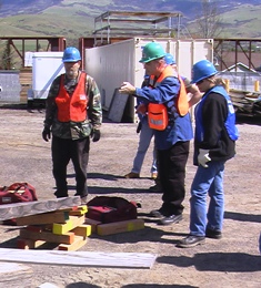 The training is fun and challenging.
- People with previous experience in emergency response will learn new techniques to be more effective.
- People with no previous experience will likely find they can do more to help
in the community during a disaster than they ever thought possible. - Hands-on segments include (deferred during pandemic) :
- Real-life Disaster Simulation: small teams apply all the skills they've learned:
keep safe, organize and communicate effectively, locate and extricate victims, classify and treat injuries. 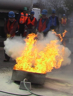 Extrication: CERT volunteers use cribbing and leverage to stabilize debris and safely extricate a victim.
Working in teams, volunteers must organize themselves with a crew leader, safety person, and crew members
who can listen carefully and follow directions. The class is taught by firefighters who make it a challenging
but fun exercise while emphasizing the importance of rescuer safety. video: cribbing- Fire and Hazmat: CERT classes offer classroom and hands-on instruction in fire suppression,
taught by firefighters from Ashland Fire and Rescue. Topics are covered first in the classroom,
then you will practice hands-on use of a fire extinguisher. Participants need protective gloves,
goggles, long pants and closed shoes for this exercise. video 2:01;
PASS: Pull pin, Aim nozzle, Squeeze handle, Sweep nozzle at base of fire - For Hazmat (hazardous materials) the CERT standard equipment includes binoculars
to recognize and get away or STAY AWAY from hazmat incidents,
so that they do not become victims themselves. - Disaster Medical: CERT volunteers spend several hours in the classroom learning disaster triage,
how to set up a medical area in a mass casualty incident, how to do basic first aid,
and how to safely transport injured victims out of the disaster area. You are trained
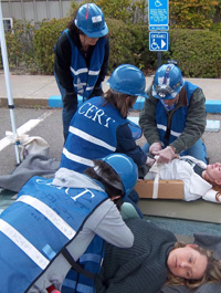 to take care of the injured and keep track of them until they are transported by ambulance.
All medical classes are taught by firefighter-paramedics. - Radio Communication: Learn to operate CERT-provided handsets and FRS radios effectively.
Communicate clearly and concisely between teams and/or command posts
using the 3 Cs template: Contact, Communicate, Confirm. - After completing a written classroom test,
an online FEMA course: IS-317.A: Introduction to Community Emergency Response Team,
and an all-day disaster simulation, congratulations you've completed Basic Training
-- the knowledge gained should be invaluable to you and your family. - After Basic Training, in order to become a CERT volunteer and assist the larger community,
complete a city background check, and more FEMA Independent Study (IS) online courses:
IS-100.C: Introduction to the Incident Command System (ICS) and
IS-700.B: An Introduction to the National Incident Management System  Active CERT members are issued a CERT photo badge and
identifying gear: helmet, vest and cap.- Gradually assemble a "ready bag" with basic supplies and PPE
(personal protective equipment). - Maintain active status by attending several meetings or
refresher mini-trainings each year. - When mobilized (and available), contribute to CERT missions,
-- activation usually via CERT Nixle message group or backup hotline:541-552-2378(-CERT)
e.g., damage assessment [on: right: Almeda, 9/8/2020],
disaster simulations, call center, parade support, etc.  Even more ways to contribute to CERT:
- assist at or manage training sessions
- volunteer as a victim -- with moulage and acting role -- for disaster simulations
- learn leadership skills
- take FEMA courses, e.g., IS-200.C: Basic ICS for Initial Response;
- Ashland: Disaster Training Opportunities;
- outreach to the community: Nixle signups, MYN Facilitator,
teach preparedness classes; - update member and training materials;
maintain supplies at bases around town; - study for your Ham license and join the Ham Radio group;
tune into the CERT Ham weekly practice net: each Mon eve
at 19:45 (7:45 pm) on the Mt. Baldy repeater (K7JAX) 146.840 (-.6; PL 123.0)
near Phoenix, OR; supported by JC ARES
Wildfire Risk Assessment Program (WRAP)
- Ashland Wildfire Safety Commission recently (3/1/2021) developed a
volunteer-based Wildfire Risk Assessment Program (WRAP): ashland.or.us/wrap
in collaboration with Oregon State University Extension and regional partners. - WRAP will train volunteers to conduct one-on-one residential wildfire risk assessments.
- Volunteer training involves six weeks of online course work, a background check,
field testing and 100 hours per year of assessment service. - Volunteer instructors will include Rogue Valley fire experts and national partners.
 Other Training and Volunteer Opportunities
- OLLI: attend/organize courses, talks or SIGs
- redcross.org: First Aid, CPR/AED, shelter management
 Jackson County Search and Rescue (JC SAR)
- Ashland Police Dept.: Volunteer
- Asante Hospitals: Volunteer
 jcares.net: Jackson County Amateur Radio Emergency Service (JC ARES)
- roguevalley.recovers.org:
Get assistance: connect with the goods and services you need.
Send supplies: connect with people who need them.
Lend a hand: connect with people who need your help. - ready.gov/volunteer: Get Trained and Volunteer:
Community Emergency Response Teams (CERT); Voluntary Organizations Active in Disaster (VOAD);
American Red Cross; Medical Reserve Corp (MRC); Neighborhood Watch & Volunteers in Police Service;
Fire Corps; Civil Air Patrol; American Radio Relay League (ARRL)
Disaster Preparedness: 11. Disaster Resources
Disaster Preparedness: 11. Disaster Resources
Resources
- Additional resources were cited in earlier sections
- General resources below are from Ashland is Ready (AIR): Emergency Preparedness Guidebook; .pdf; 2017
Ashland Community Emergency Response Team (CERT)
Ashland Emergency Radio Frequency
Ashland Fire & Rescue Non-Emergency Line
Ashland Fire & Rescue Smoke and Wildfire Hotline
Ashland Firewise
Centers for Disease Control (CDC)
Citizen Alert (Nixle)
City of Ashland
Department of Homeland Security
Disaster Registry (Rogue Valley)
Federal Emergency Management Agency (FEMA)
Jackson County Health & Human Services (HHS)
National Fire Protection Agency (NFPA)
National Oceanic and Atmospheric Administration (NOAA)
National Weather Service
Oregon Department of Environmental Quality (DEQ)
Oregon Department of Forestry Wildfire Information (ODF)
Oregon Department of Geology (DOGAMI)
Oregon Department of Transportation (ODOT) Trip Check
Oregon Office of Emergency Management (OEM)
Oregon Smoke Information
Pacific Northwest Seismic Network
United States Geological Survey (USGS)
ashlandcert.org
1700AM
541-482-2770
541-552-2490
ashlandfirewise.org
cdc.gov
ashland.or.us/alert
ashland.or.us
ready.gov
rvcog.org/disaster-registry
fema.gov
jacksoncountyor.org/hhs/public-health
noaa.gov
weather.gov
oregon.gov/deq
facebook.com/odfsouthwest
oregongeology.org
tripcheck.com
oregon.gov/oem
oregonsmoke.blogspot.com
pnsn.org
usgs.gov