Emergency Preparedness
 Introduction
- Do you want your family, neighborhood and community to be better prepared in case of disaster,
e.g., wildfire, Cascadia earthquake, etc.?
- With Ashland CERT: ashlandcert.org (Community Emergency Response Team) since ~2010,
I have been learning about medical triage, disaster planning and response,
team organization, and radio communications
-- and assisting with training and Map Your Neighborhood (MYN): ashland.or.us/myn.
- An OLLI Course: Disaster Preparedness: Almeda, Cascadia, Zombies
provides the latest advice and resources.
- A few older / specialized resources:
- 2-page .pdf with selected resources w/ live links; updated: 5/2019
- Ham Radio, Maps, etc. appear on separate pages
- additional disaster-related articles from my OLLI course: Be Safer on the Internet: Backups: Disaster
Ham Radio
 Introduction
- After study sessions with other AshlandCERT.org members,
I obtained my Technical and General Ham licenses in Summer 2018.
- My main interest: emergency communication on VHF and UHF bands,
e.g., if cell phones, landlines and internet fail after Cascadia earthquake.
- To improve my skills, I often check-in and train on a 'weekly net'
-- usually via repeaters, sometimes with simplex (radio-to-radio) exercises.
- attend a monthly meeting with other CERT Hams,
- and provide radio support for public events, e.g., MLK Day, 4th of July parade, etc.
- My call sign:
K7SWX.
- My radios:
- Handheld: Baofeng UV82-C, 5w (output power), VHF&UHF;
several antennas: 'rubber duck', whip, mag mount, J-pole
- Mobile: Kenwood TM-281A, 25w/65w, VHF-only
-- plus X-50A antenna (when home)
- Summary from OLLI Course: Disaster Preparedness: Be Informed: Alerts and Communications
Resources
Maps
Introduction
- "I got myself a senior's GPS...
Not only does it tell me how to get to my destination,
it tells me why I wanted to go there.
- CERT members may need to find / report locations during Search and Rescue (SAR) and radio operations.
- Street signs and house numbers may be missing / unreadable after a disaster.
- A dedicated GPS device or smartphone (even in Airplane mode) can identify current location,
navigate to coordinates, set waypoints, etc.
- A cellular-capable iPad (w/ SIM slot) has GPS and compass too
-- even though built-in Compass app has been removed.
- iPad:
Settings > Location Services > System Services > Compass Calibration: enable
- Apps: Internet (Wi-Fi or cell data plan) required to download from app store
-- preinstall (at a minimum): Avenza Maps, Coordinates, etc.
(other apps listed below for features, preferred interface/use, or historical reasons)
- Maps: Since mobile internet accesss may be spotty in the field, or completely unavailable during a disaster,
offline maps are critical -- preferably downloaded in advance, or later via peer-to-peer,
e.g., AirDrop (iOS), or local WiFi intranet.
- The Best Hiking Apps to Keep from Getting Lost
offline options: AllTrails Pro, Gaia GPS, Guthook Guides, Google Maps; Wired; 9/19/2021
- Best Offline Map Apps for iPhone and iPad in 2020
Google Maps; Sygic GPS Navigation & Maps; Maps.me; CityMaps2Go; TrailLink; HERE WeGo City Navigation;
OsmAnd Maps; Guru Maps; Pocket Earth Maps Magic Earth Navigation and Maps;
note: Apple Maps: no offline capability -- beyond what's cached
- Devices and apps discussed in next sections support UTM/USNG coordinates,
in addition to latitude/longitude, unless otherwise noted.
- Sections:
- GPS Coordinates
- GPS Devices
- app: Avenza Maps -- and Geospatial PDFs
- app: Coordinates
- app: Compass
- app: Google Maps
- app: GPS & Map Toolbox
- app: Gaia GPS
- apps: CalTopo, SARTopo
- app: Maps.me
- app: Topo Maps
GPS Coordinates
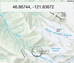
- Geographic coordinate systems, e.g., latitude/longitude or UTM, are used by different organizations and purposes.
- CERT and SAR prefer metric coordinates: Universal Transverse Mercator (UTM)
or US National Grid (USNG), which is the same as MGRS used by the US military and NATO.
- Aircraft and ships prefer lat/long coordinates.
Note: lat/long are longer than UTM/USNG (for the same precision),
more unwieldly/complex for communication and calculation.
- Although using UTM/USNG primarily, CERT members are expected to be familiar with different lat/long formats.
- UTM/USNG coordinates can be plotted easily on topo/gridded maps.
- 15-17 characters uniquely identify a single one-meter grid square out of the entire surface of the earth.
- distance in meters[5 digits] -- or 10 m[4], 100 m[3], 1000 m[2] -- "read right (easting) and then up (northing)"
from lower-left corner of grid zone square, to lower-left of target square
- These metric offsets from the grid square origin are the same for UTM and USNG/MGRS.
- However, conventions for specifying the surrounding 100km x 100km square are different for UTM and USNG.
- Anatomy of an example UTM/USNG coordinate:
- UTM: 10T 05 24041 46 71369; USNG: 10T EM 24041 71369
- [both:=3] grid zone -- same for both UTM and USNG; 10T = SW Oregon
- UTM: 10T 05 24041 46 71369; USNG: 10T EM 24041 71369
- [UTM:=2] 'easting', e.g., 05; with 'northing' identifies 100 km x 100 km square (maybe omitted depending on context)
- [USNG:=2] 100 km x 100 km square, e.g., EM (maybe omitted depending on context) -- both easting & northing
- UTM: 10T 05 24041 46 71369; USNG: 10T EM 24041 71369
- [both:=2-5] dist. right ('easting') of left corner -- here, 1 m. resolution)
- UTM: 10T 05 24041 46 71369; USNG: 10T EM 24041 71369
- [UTM:=2] 'northing'; maybe omitted depending on context
- [USNG:=0] already specified, e.g., EM
- UTM: 10T 05 24041 46 71369; USNG: 10T EM 24041 71369
- [both:=2-5] dist. above ('northing') bottom corner
- Examples: comparing different coordinate formats; some [options] maybe omitted due to context for shorter messages
- physical address: Ashland Fire Station 1, 455 Siskiyou Blvd. [corner: E. Main St.], Ashland, [OR] [97520]
- UTM: [10T] [05] 24041 [easting] [46] 71369 [northing] (1 meter resolution)
- USNG: [10T EM] 24041 71369 (same as MGRS)
- UTM&USNG: 24041 71369 (1 m res.; coords. within same implicit zone and grid square)
- USNG: 10T EM 24 71 (1 km res.; fewer digits for terser messages)
- Latitude/Longitude (decimal degrees): 42.19411° [N], [-]122.70882° [W]
- Lat/Long (dec. minutes): 42° 11.646' [N], [-]122° 42.529' [W]
- Lat/Long (dec. seconds): 42° 11' 38.8" [N], [-]122° 42' 31.8" [W]
- Converters between formats: NGS Coordinate Conversion and Transformation Tool (NCAT);
Earthpoint; also many apps
- gps-coordinates.org: distance between coordinates
- usngapp.org; 3-4 digit USNG (only) coordinates for current location in large font
- The Story of GPS the dot and the map; Road&Track; 5/27/2021
- Can This New Map Fix Our Distorted Views of the World? NYT; 2/24/2021
- America's GPS System is Essential but also Vulnerable. We Need a Backup NYT; 1/23/2021
- Crossword: NYT Learning Network: Latitude & Longitude
- what3words: a system that divides world into 57 trillion 3m x 3m squares, each with a unique 3 word address;
e.g., Ashland FS1: contemplate.requested.booked; what3words is touted in press as boon to SAR,
but why download a separate app (with proprietary, copyrighted format)
when phone can just send standard coordinates directly?
- Wikipedia: what3words
- What3words: The app that can save your life But...
- What3words Is A Clever Way Of Communicating Position Very Simply,
But Do We Really Want To Create A Monopoly For Location Look-ups?
GPS Devices
- Many dedicated GPS devices are available. Recommendations, e.g., Garmin eTrex 20x?
- REI Expert Guides: How to Choose and Use a GPS; How to Choose Between a PLB and a Satellite Messenger
- I have a Garmin inReach Explorer+, with map navigation capability (on a small screen)
- inReach can also be used in emergencies (with a subscription plan) to contact search&rescue
or family/friends via 2-way satellite texting (pre-composed or custom messages)
-- when no cellular or internet access is available, e.g., backcountry, remote roads, regional disasters.
 app: Avenza Maps -- and Geospatial PDFs
- iOS, Android; free version supports 3 active maps; paid subscription for unlimited maps and more features
- a Geospatial PDF (aka geo-enabled, georeferenced*) has embedded GIS data linking
a map region to its real-world coordinates;
example uses: locate/view coordinates for a specific point, measure a distance/area
*(GeoPDF would be most convenient shorthand -- except for TerraGo's trademark)
- Besides Avenza, other tools are available to create geospatial PDFs;
e.g., free web-based Caltopo.com (intro)
- A non-geospatial PDF appears in Avenza with status: "Map not referenced"
- Before downloading any large maps to device, alternatively, check geospatial status first on desktop?
- e.g., Adobe Acrobat Reader (guide), or other desktop mapping tool
- Reader:
Tools > Measure > Geospatial Location Tool
- Click in map. Does Latitude / Longitude update as cursor moves? If yes, geospatial.
- Note: Acrobat X (and later versions) removed option to display USNG (and other formats) .
- Save geospatial .pdfs locally on device for offline access -- not to cloud storage, since internet may be unavail later.
- directly to Avenza Maps -- or if limited to 3 maps (in free version), store pdf in another app,
e.g., iOS: GoodReader or Files app
- later:
GoodReader > [share] > Open In (Send As Is) > copy to Avenza Maps,
or AirDrop to someone.
- Geospatial map sources (note: if UTM coords. appear corrupt for some maps, switch to USNG display format)
- Avenza search by area, filter by cost (some free); can download only to Avenza Maps app?
- SW Oregon Dept. of Forestry (ODF); e.g., Jackson County South (Ashland) only major streets
- USGS quads (free): USGS Store; TNM map interface/downloader
- US National Park Service (NPS)
- US Bureau of Land Management (BLM) free, via Avenza Map Store
- US Forest Service: FSTopomap
- OR Dept. of Fish and Wildlife (ODFW)
- geospatial: some
- City of Ashland: e.g., Transportation: Street Map w/ Index (2014); Parks: Lithia Park; Parks: Trails: Lithia Loop
- OR Dept. of Trans. (ODOT) -- none yet on public site;
I requested these geospatial versions: Ashland; Jackson County #4 Ashland-Eagle Point-Mt. McLoughlin-Pinehurst-Ashland
- iOS; Android (soon?); free (ads); displays / converts multiple coordinate formats in large font
- if online, uses Apple Maps; if offline, global (non-detailed) map
app: Compass
- iPhone: built-in (free); (removed from cellular, compass-capable iPads); direction, lat/long (only) coordinates
- How to Get Your Current GPS Coordinates on iPhone with Siri
(requires an active internet connection or cell phone service)
1. Summon Siri and ask “What are my current GPS Coordinates?”
2. Siri will show you your current location, scroll down to see
your current GPS Coordinates (latitude and longitude) (vs. Compass)
- iOS, Android; browser; free; 3-4 digit USNG (only) coordinates for current location in large font;
no map; instead use Coordinates?
- iOS; basic version: $2, lat/long only; Pro version: other coordinate formats & tools
- CalTopo (macOS; Win) & SARTopo (macOS; Win) Desktop apps for offline access
to maps from online SARTopo.com web site
- requirements: SARTopo.com account with offline privileges; installation of Java Standard Edition (SDK)
- I have not tried these...; recommended by Dan R.
 app: Coordinates
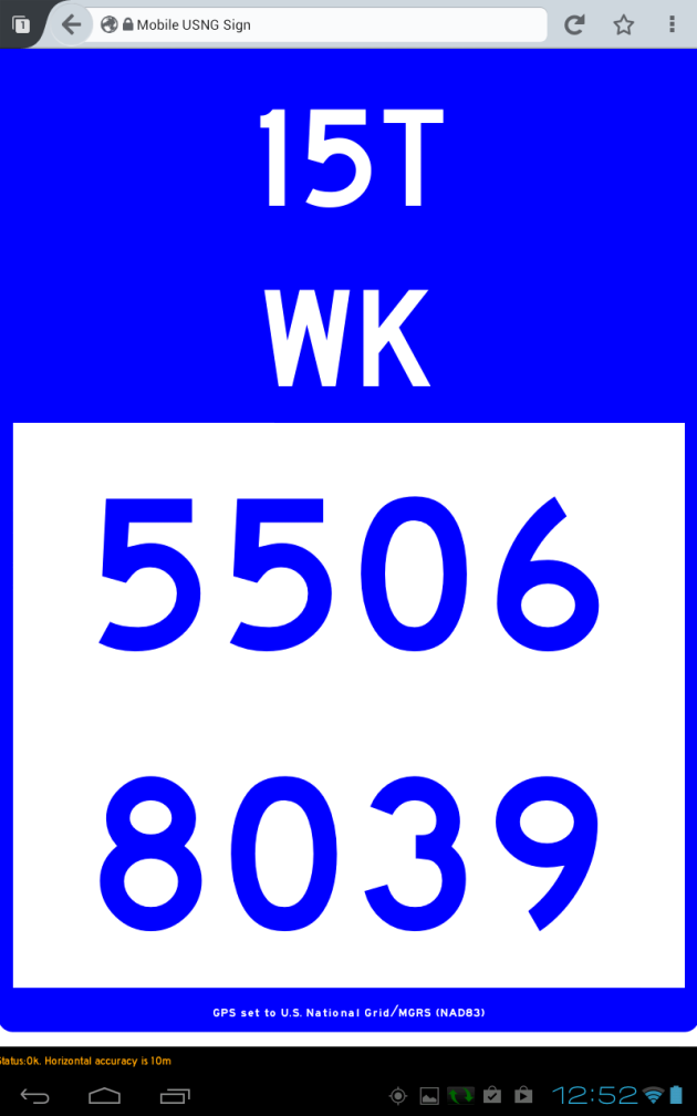 app: USNGapp