Apps: Internet (Wi-Fi or cell data plan) required to download from app store
-- preinstall (at a minimum): Avenza Maps, Coordinates, etc. (other apps listed below for features, preferred interface/use, or historical reasons)
Maps: Since mobile internet accesss may be spotty in the field, or completely unavailable during a disaster,
offline maps are critical -- preferably downloaded in advance, or later via peer-to-peer,
e.g., AirDrop (iOS), or local WiFi intranet.
Best Offline Map Apps for iPhone and iPad in 2020
Google Maps; Sygic GPS Navigation & Maps; Maps.me; CityMaps2Go; TrailLink; HERE WeGo City Navigation;
OsmAnd Maps; Guru Maps; Pocket Earth Maps Magic Earth Navigation and Maps;
note: Apple Maps: no offline capability -- beyond what's cached
Devices and apps discussed in next sections support UTM/USNG coordinates,
in addition to latitude/longitude, unless otherwise noted.
Aircraft and ships prefer lat/long coordinates.
Note: lat/long are longer than UTM/USNG (for the same precision),
more unwieldly/complex for communication and calculation.
Although using UTM/USNG primarily, CERT members are expected to be familiar with different lat/long formats.
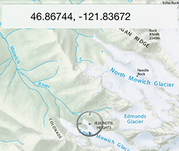
UTM/USNG coordinates can be plotted easily on topo/gridded maps.
15-17 characters uniquely identify a single one-meter grid square out of the entire surface of the earth.
distance in meters[5 digits] -- or 10 m[4], 100 m[3], 1000 m[2] -- "read right (easting) and then up (northing)"
from lower-left corner of grid zone square, to lower-left of target square
These metric offsets from the grid square origin are the same for UTM and USNG/MGRS.
However, conventions for specifying the surrounding 100km x 100km square are different for UTM and USNG.
what3words: a system that divides world into 57 trillion 3m x 3m squares, each with a unique 3 word address;
e.g., Ashland FS1: contemplate.requested.booked; what3words is touted in press as boon to SAR,
but why download a separate app (with proprietary, copyrighted format)
when phone can just send standard coordinates directly?
inReach can also be used in emergencies (with a subscription plan) to contact search&rescue
or family/friends via 2-way satellite texting (pre-composed or custom messages)
-- when no cellular or internet access is available, e.g., backcountry, remote roads, regional disasters.
iOS, Android; free version supports 3 active maps; paid subscription for unlimited maps and more features
a Geospatial PDF (aka geo-enabled, georeferenced*) has embedded GIS data linking
a map region to its real-world coordinates;
example uses: locate/view coordinates for a specific point, measure a distance/area
*(GeoPDF would be most convenient shorthand -- except for TerraGo's trademark)
Besides Avenza, other tools are available to create geospatial PDFs;
e.g., free web-based Caltopo.com (intro)
A non-geospatial PDF appears in Avenza with status: "Map not referenced"
Before downloading any large maps to device, alternatively, check geospatial status first on desktop?
How to Get Your Current GPS Coordinates on iPhone with Siri
(requires an active internet connection or cell phone service)
1. Summon Siri and ask “What are my current GPS Coordinates?”
2. Siri will show you your current location, scroll down to see
your current GPS Coordinates (latitude and longitude) (vs. Compass)
 app: Avenza Maps -- and Geospatial PDFs
 app: Coordinates
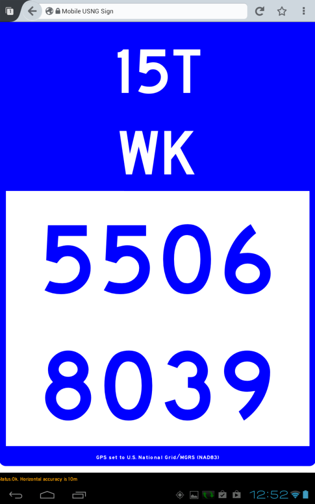 app: USNGapp