Introduction | JC Citizen Alert |
Emergency Alert Systems: EAS, WEA, ShakeAlert |
Sirens | In-person | Phones; Texting |
TV; Radio | Official Websites; Social Media | Apps
Public domain, via Wikimedia Commons"
Make sure your NOAA radio is properly set
so you will be notified about disasters or severe weather.
Introduction
- An authorized public safety official is available and
creates a message to distribute. Message sent? - A resident has a working device. Turned on?
Message received and noticed?
Language and content understood? - Electricity, landlines, cell towers and/or internet
may be down or unreliable/overloaded. - Do you have redundant ways to receive alerts and trustworthy info,
especially if your preferred ways aren't accessible? - Understand the evacuation levels (next section) used in communications:
 Level 1: Be Ready -- you have a plan; monitor emergency info; know what to take, start to pack
- Level 2: Set -- everything packed at front door or already in car
- Level 3: Go -- evacuate now!
- ready.gov: Alerts, Get Tech Ready
 Jackson County Citizen Alert (Everbridge): rvem.org
Ashland
- Ashland has switched to Citizen Alert (like Jackson County) from earlier "Nixle" system;
some historical (Almeda) info is included. - Ashland citizens are encouraged to create a new account with Citizen Alert replaces Nixle; Ash; 8/11/2023
- Sign up here: ashland.or.us/alerts for most options;
Text:97520 to 888777to sign up for emergency text Alerts, only - optional: Text:
WATERSHED to 888777for Controlled Burn Alerts - Nixle Messages 9/8/2020 - 9/11/2020
- Almeda After Action Review (AAR):
Lessons Learned, .pdf; 30 pp. 12/20; some of the Ashland survey questions:
Were you enrolled in Nixle before the Almeda Fire on Sep. 8th?
Did you find the Level of communication through Nixle to be adequate during the Almeda Fire’s active phase?
How did you access Almeda Fire resources or informational updates from the City?
How could the City have improved its notification process for you?
During the Almeda Fire, were you ever personally advised to evacuate immediately?
Elsewhere in Jackson County
- 1. listed landlines called automatically; "reverse 911"
 2. Text:
 JACKSONEVACS to 888777to sign up
for emergency text Alerts, only- 3. Sign-up: rvem.org or jacksoncounty.org/alert for email, text and/or voice alerts;
be sure to Edit and check alert options [on right]; Josephine County also - video: How to sign up for Citizen Alert for evacuation notices
 and why not to wait for someone to knock on your door
 - Talent: Citizen Alert -- Sign Up Today!
- Citzen Alert uses the Everbridge system (Wikipedia).
- Sign-up for Special (Senior or Disabled) Assistance during/after a disaster:
Rogue Valley Council of Governments: Disaster Registry: rvcog.org
 Emergency Alert Systems EAS: TV, Radio: WEA: Cell phones; ShakeAlert
- e.g., AMBER, Presidential, severe weather alerts, ShakeAlert, Citizen Alert (Everbridge)
- Integrated Public Alert & Warning System (IPAWS): FEMA's national system for local alerting
that provides authenticated emergency and life-saving information to the public
through mobile phones using Wireless Emergency Alerts (WEA),
to radio and television via the Emergency Alert System (EAS), and
on the National Oceanic and Atmospheric Administration's Weather Radio (NOAA). - fema.gov: EAS, WEA; weather.gov: NOAA
 ready.gov: EAS, WEA, NOAA; fcc.gov: EAS, WEA
Emergency Alert System (EAS)
- EAS (TV/Radio) : national public warning system commonly used
by federal, state and local authorities
to deliver important emergency information,
such as weather and AMBER alerts, to affected communities
via broadcast & satellite radio and TV providers,
cable systems, and wireline video providers. - TV or radio: turned on, volume audible?

 Wireless Emergency Alerts (WEA)
- WEA: critical warnings and information
from authorized public safety officials
to the public in affected areas on their wireless devices - Some of these alerts might look like text messages but
they are not, and are thus not affected by network congestion
that may affect regular mobile voice or text messaging services. - The alert is accompanied by a unique attention signal and vibration,
which is particularly helpful to people with hearing or vision-related disabilities. 
 Cell phone: powered on; Airplane Mode: off; within cell tower range;
emergency notifications: enabled [right: Android, iOS]?- You should receive and hear notifications even if you've
enabled Do Not Disturb, blocked unknown callers, or used the mute button. - Everbridge has been IPAWS-certified by FEMA,
so notifications via Citizen Alert should also be received,
assuming the same phone settings above. - FCC: How to Opt In to Wireless Emergency Alert Tests And, iOS; .pdf
- Nationwide Alert Will Reach Cellphones, TVs and Radios on Wed (10/4/2023) NYT; 10/4/2023
- Maui Sent an Evacuation Alert. Why Did So Few People Get It? shortcomings of a wireless alert system; NYT; 9/3/2023
- Emergency SOS via satellite: Where and how the life-saving iPhone feature works MW; 3/7/2023
- "Huge flaw" threatens US emergency alert system, DHS researcher warns
hackers can disrupt legit EAS (TV/radio) warnings or issue fake ones of their own; Ars; 8/4/2022 - Why your iPhone didn’t get the August 2021 wireless emergency alert test
Android phones have a toggle for emergency alert tests in Settings,
iPhones do not -- manually call: *5005*25371#; MW; 8/16/2021 - Use Emergency Bypass to Circumvent Do Not Disturb for VIPs
Contacts > (Citizen Alert #) > Edit >

Ringtone and/or Text Tone > Enable Emergency Bypass > Done
iOS; TidBits; 4/1/2021 - Texas Department Apologizes for 'Chucky' Amber Alert test; NYT; 2/3/2021
- Some in the Path of Oregon's Wildfires Never Got Evacuation Alerts
local officials declined to activate their Emergency Alert System,
leaving television and radio programs uninterrupted
and sending emergency alerts only to residents who had signed up
for an online notification system; NYT; 9/25/2020 - County defends decision to not use mass emergency alert system for Almeda fire
Citizen Alert notification system can warn people in a specific area, like Talent and Phoenix,
as opposed to the whole county -- assuming people without landlines have enrolled; KOBI5; 9/16/2020 - Hawaii Panics After Alert About Incoming Missile Is Sent in Error NYT; 1/13/2018
- Inside the Decades-Long Fight for Better Emergency Alerts Wired; 11/14/2017
 ShakeAlert
- "Earthquake Detected! Drop, Cover, Hold On. Protect Yourself. -USGS ShakeAlert"
- "Terremoto detectado! Agachese, cubrase, sujetese. Protejase. -USGS ShakeAlert"
- ShakeAlert from USGS is an
earthquake early warning (EEW) system that
detects significant earthquakes so quickly that
alerts can reach many people before shaking arrives. - ShakeAlert is not earthquake prediction,
rather a ShakeAlert Message indicates that an
earthquake has begun and shaking is imminent. - Based on location and the magnitude of
P-wave (primary, pressure) information from sensors,
the method can provide warning seconds*
before slower S-wave (secondary, shear,
side-to-side, surface) arrives, bringing the strong shaking
that usually causes most of the damage. - *Number of seconds of warning depends on location of epicenter,
rock types, speed of signal detection & processing, message distribution:
:00 -- at OR Coast (seismometers on land, rather than deep offshore)
:20-:30 -- in Rogue Valley for Cascadia event off So. OR coast
:30+ -- in Rogue Valley, if epicenter farther north - If ShakeAlert is enabled in your area, i.e., CA (10/2019), OR (3/2021), WA (5/2021),
messages are sent via: WEA (emergency alerts) or a ShakeAlert app - Note: WEA is sent out via a different protocol.
WEA delivery had been measured in 10s of minutes but hopefully improving; app should be faster.
WEA is a general alert sent out to a very wide area but can reach more people w/o an app install.
The app alert will be specific to the user since it knows the location.
Both are needed in order to deliver the most alerts they can. - Phone OS may provide built-in alerts and detection (accelerometer as mini-seismometer);
Android 5+: integrated support;
iOS: 3rd-party seismometer apps only, currently? - Slightly different alerting thresholds for the different alert delivery types (from Eric Ditmer):
- Wireless Emergency Alerts (WEA): M5.0+ and MMI 4+
- apps, Android: M4.5+ and MMI 3+
- M = Magnitude (Richter, etc.); MMI = Modified Mercalli Intensity;
comparison: M vs. MMI - video: 4:38; shakealert.org; note: QuakeAlertUSA app is no longer available
- Seconds before a 6.2 earthquake rattled California, phones got a vital warning
ShakeAlert; Guardian; 12/21/2021 - Entire U.S. West Coast Now Covered By
Earthquake Early Warning System NPR; 5/5/2021 - Earthquake early warning now available to Oregon public
Governor Kate Brown today proclaimed 3/11/2021 as
ShakeAlert Day, in recognition of the activation of the
ShakeAlert Earthquake Early Warning System in Oregon,
and the day that coincides with the 10th anniversary of
the magnitude 9.1 Great Tohoku, Japan earthquake.
Alerting is now available directly to individual wireless
devices in Oregon -
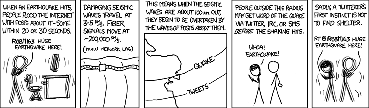
Seismic Waves by XKCD is licensed under a
Creative Commons Attribution-NonCommercial 2.5 LicenseShakeAlert in Oregon oregon.gov/oem; 3/11/2021
- Oregon's ShakeAlert Earthquake Warning System
Approved for State Funding
legislature approved $7.5 million to fund Oregon’s ShakeAlert
system during their one-day special session; NPR; 8/11/2020 - 5 new things your Android phone can do:
#2. Get alerted to earthquakes around you
Android 5.0 and above, devices with accelerometers; 8/11/2020
 Sirens
- Sirens can be highly effective if heard and the meaning is clear,
i.e., what is the disaster, who is affected, what to do / where to go? - At a minimum, sirens can provide a "wakeup call" if you or your devices are asleep.
- Check trusted sources for further info and guidance, e.g., Citizen Alert, official web sites, Radio, etc.
- In tornado zones, a siren means: tornado! go to your shelter now.

 In Ashland, sirens (=~4) audible in the flood zone along
Ashland Creek are followed by one of these messages
about Hosler Dam (at Reeder Reservoir):- 1. "This is a test of the Hosler Dam warning system.
This is only a test." - 2. "Hosler Dam Emergency.
Evacuate the flood hazard zone immediately." - 3. "Hosler Dam is secure.
It is safe to return to the flood hazard zone." - Hosler Dam Early Warning System .pdf; includes flood zone map
- video: Ashland tests Hosler Dam flood warning sirens 0:40
- Other creeks and tributaries can flood: Jackson County Floodplain Maps
In-person Notification
Before a Disaster
- Public Safety Officers (police, fire) may drive along streets with sirens or loudspeakers.
- If safe, available officials and CERT Volunteers may systematically canvass neighborhoods door-to-door.
- If you received an official notification, e.g., Citizen Alert,
contact nearby neighbors who are unaware, may not understand English or may need extra assistance;
e.g., their needs shared earlier via Map Your Neighborhood (MYN) - CERT team members alerted MYN neighbors in Talent MYN; Mail Tribune; 11/2/2020
- Don't rely on personal notification -- there may not have been time or personnel available.
If you do receive one personal evacuation warning, don't expect a second visit.
After a Disaster
- MYN neighbors may check on and help each other.
- CERT teams may canvass neighborhoods, survey damage, triage and treat injuries, and perform light search&rescue.
 Phones: Hotlines/Recordings; Texting
- Ashland Wildfire and Smoke:
541-552-2490;
541-552-2378(-CERT): backup for CERT members who missed activation messages - Jackson County: Emergency Management:
541-776-7338;
Civil Emergency Hotline:541-776-7339;
Sheriff:541-774-6800 - Josephine County Emergency Management:
541-474-5305 - 911 may be overloaded / unavailable.
- Hardwired landlines (non-wireless handsets; non-VOIP) may function, even if power is out.
- Cell service -- if available -- will likely be overloaded.
- See WEA above for Wireless Emergency Alerts
- Regular (SMS) texting may be more successful
than voice calls or internet-based messaging. - How to Activate Emergency SOS on iPhone OSXD; 7/28/2021
- some organizations with text messaging options:
Jackson County, e.g., Citizen Alert;
FEMA, e.g., Shelters, Recovery Centers;
Red Cross, e.g., Weather and Emergency Alerts - Here's what it’s like to use Apple's Emergency SOS via satellite Verge; 11/15/2022
 Apple Says More about Emergency SOS via Satellite Technology TB; 11/11/2022
- Apple's Emergency SOS link puts it into the satellite fight with SpaceX and more iPhone 14 and 14 Pro; Verge; 9/8/2022
- Garmin inReach Explorer+ (GPS, map & texting unit; with subscription plan) [on right]
can be used in emergencies to contact search&rescue or family/friends
with pre-composed or custom messages via 2-way satellite texting
-- even when no cellular or internet access is available,
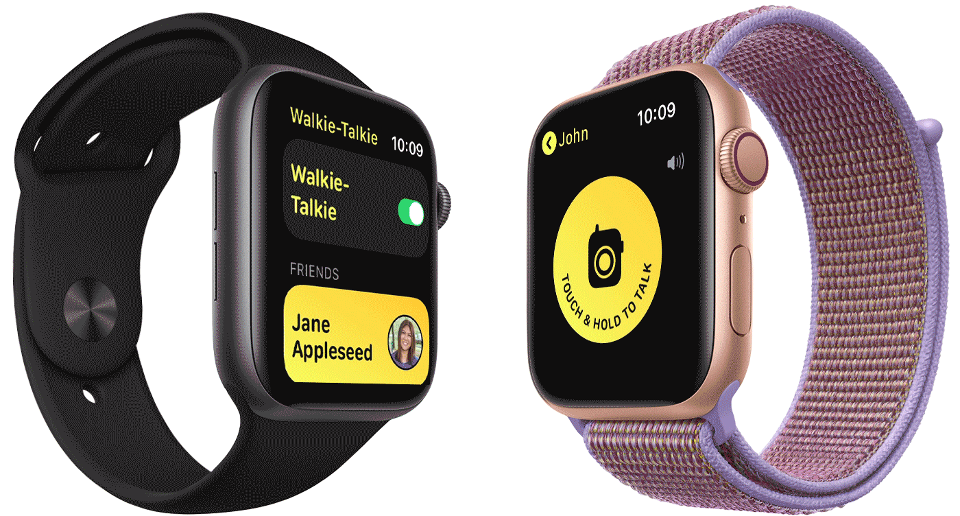
e.g., regional disasters, backcountry, remote roads.  Apple: Use Walkie-Talkie on your Apple Watch watchOS 7 docs;
animated demo; over internet connection from paired iPhone,
or on watch (Wi-Fi or built-in cell capability)
 TV; Radio: AM/FM, NOAA, FRS, GMRS, MURS, Public Safety, Ham, CB
- Ashland Emergency Radio Station: 1700 AM
- Use your car's radio if you don't have a separate battery-operated radio.
- Aside from EAS alerts, general TV & Radio news broadcasts
may not be as current and accurate as other methods. - Blanket evacuation orders may make the disaster worse,
e.g., traffic jams with unnecessary Level 1-2 evacuees. -

Mark Trail Champions NOAA Weather Radio;
www.weather.gov/nwr/In US, FCC oversees these frequencies:
- UHF Ultra High Frequency: 300 megahertz (MHz) to 3 gigahertz (GHz);
wavelengths (band): 1 meter (m) to 0.1 m;
e.g., FRS, GMRS; Ham; broadcast TV; Wi-Fi (2.4Ghz);
cell networks ('3G', i.e., 3rd gen.); cordless phones - VHF Very High Frequency: 30 to 300 MHz; 10 m to 1 m;
e.g., NOAA; MURS; Public Safety; Ham; broadcast TV; FM - HF High Frequency: 3 to 30 MHz; 100 m to 10 m; e.g., CB; Ham ('shortwave')
- MF Medium Frequency: 300 kilohertz (kHz) to 3 MHz; 1000 m to 100 m; e.g., AM
- other frequency ranges: Electromagnetic spectrum
- transmission range (distance) depends on many factors:
more range with lower frequency, higher output power, longer antenna,
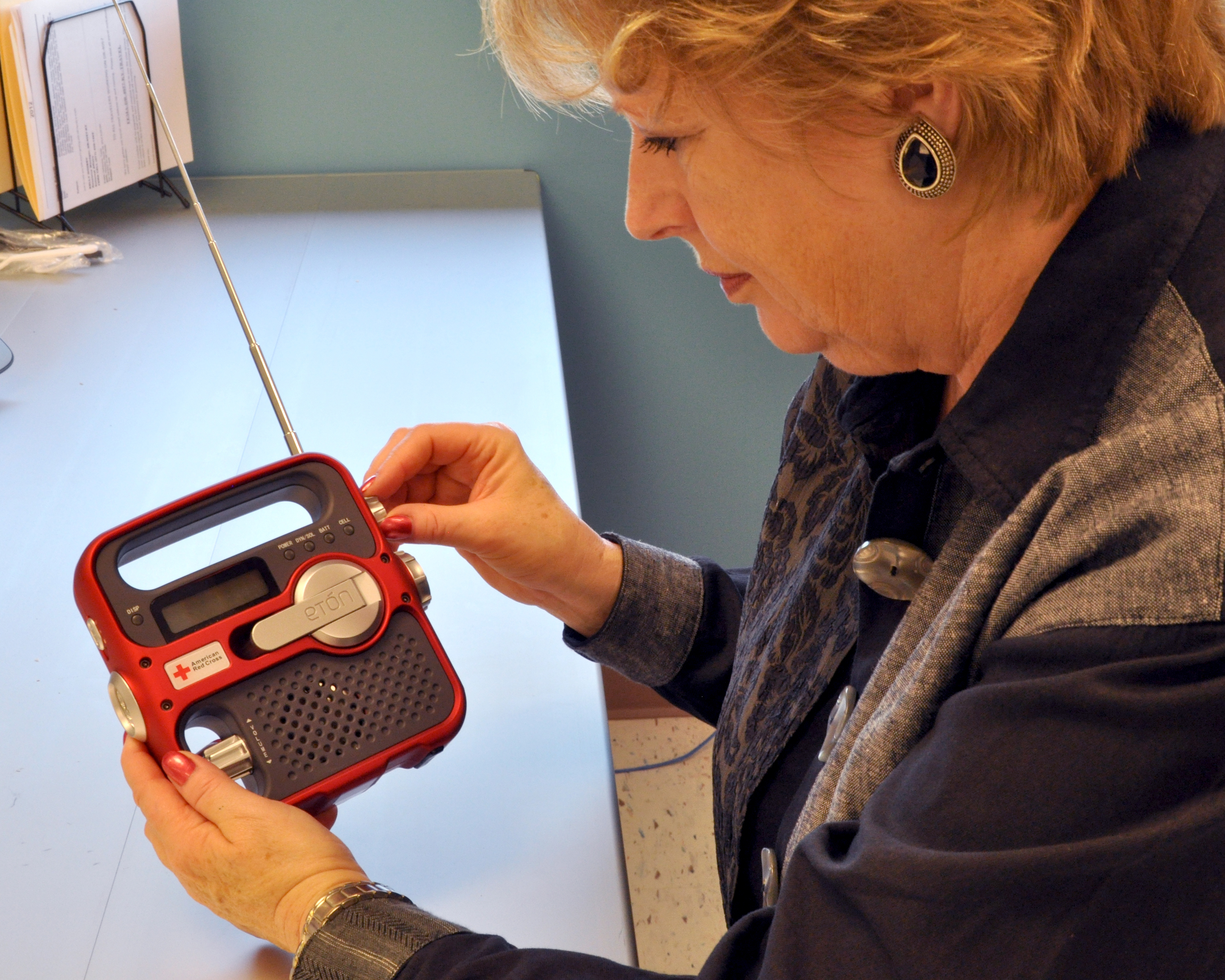
proper radio positioning, fewer line-of-sight obstructions - NOAA Weather Radio All Hazards receive-only; no license required; VHF;
inexpensive; for home and/or go-bag; periodically test, recharge battery;
some models recharge via handcrank, USB and/or tiny solar;
 may have AM/FM stations, flashlight; Wikipedia: NOAA
NOAA stations also avail via Broadcastify - Some walkie-talkies (FRS) include NOAA channels -- check your user manual
- 7 channels should be standard, numbered 1-7, usually named "WX1-WX7"
- NOAA channel; VHF freq. (MHz):
1. WX2: 162.400  (Medford); 2. WX4: 162.425; 3. WX5: 162.450;

4. WX3: 162.475 (Mt. Ashland); 5. WX6: 162.500; 6. WX7: 162.525; 7. WX1: 162.550
additional:161.650; 161.750; 161.775; 162.000; 163.275 - Family Service Radios (FRS) aka "walkie talkies": local, two-way messaging and coordination; UHF;
 low output power: 0.5-2w (short-range); no license required; limited channels; inexpensive; congested?
Wikipedia: FRS; some include NOAA channels -- how to recharge during power outage? - FRS channel (output power); UHF freq. (MHz):
1-7 (2w):462.5625; 462.5875; 462.6125; 462.6375; 462.6625; 462.6875; 462.7125
8-14 (0.5w):467.5625; 467.5875; 467.6125; 467.6375; 467.6625; 467.6875; 467.7125
15-22 (2w):462.550; 462.575; 462.600; 462.625; 462.650; 462.675; 462.700; 462.725 - General Mobile Radio Service (GMRS): frequency overlap* with FRS; UHF;
higher output power -- up to 50w on some frequencies; requires license; Wikipedia: GMRS - GMRS channel (output power); UHF freq. (MHz):
1-7 (5w), 8-14 (0.5w), 15-22 (50w) -- *same FRS frequencies;
additional (50w):467.550; 467.575; 467.600; 467.625; 467.650; 467.675; 467.700; 467.725 - Multi-Use Radio Service (MURS): low power like FRS; no license required; Wikipedia: MURS; VHF
- MURS channel (output power); VHF freq. (MHz):
1-5 (2w):151.82; 151.88; 151.94; 154.57; 154.60 - Citizens Band (CB): no license required; longer range; HF
- Public Safety (PS): police and fire dispatcher traffic; VHF; anyone can listen, e.g., channel scanner;
non-radio access: Broadcastify: Jackson County or apps: Broadcastify, Pulsepoint;
very immediate and unfiltered local operational details -- not a source of advice or context.
 CERT teams may be authorized to transmit on selected channels for official missions and training.
 - Amateur Radio Service aka "Ham"; VHF, UHF, HF; anyone can listen*; live, unfiltered info;
*two-way requires Ham license ('Technician': VHF,UHF; 'General': HF; Morse code no longer tested);
typical form factors, output power: handheld (like FRS; 5w), mobile (vehicle; 25-65w), base station (50-100w);
Jackson Co. (JC) Amateur Radio Emergency Service (ARES); Wikipedia: Ham; Steve: Ham
 Official Websites; Social Media
- Public safety websites should be updated frequently during disaster;
their official social media sites/apps (e.g., FB = Facebook) would be trustworthy,
and may be updated even more quickly
-- assuming home internet or mobile data is available.
Authorized, knowledgeable personnel may not have time to duplicate
information and answer questions on other sites, e.g., NextDoor - Non-official websites and social media may provide advertising, gossip,
rumors, conspiracy theories, etc. -- so are generally not recommended
as reliable sources of disaster news and advice. - Ashland Fire & Rescue: site; FB; CERT;
Ashland Police: site; FB;
City of Ashland: site; FB; Trusted Organizations;
Ashland Forest Resiliency Project: Controlled Burn & Trail Info: ashland.or.us/trailinfo - Medford: Fire Dept. (FB);
Police (FB);
City (FB) - Jackson County: Fire District 3 (FB);
Sheriff: site; FB;
Emergency Management: site; FB - JCEM FB Posts: 9/8/2020 - 9/12/2020; .pdf; e.g., above right
 Live Evacuation Map [right], with links (now inactive):
Missing Persons Form and Evacuation Check In
(another option: RedCross: Safe and Well)- jacksoncountyor.org (backup site: jacksoncounty.org)
- Ransomware attack shuts Jackson County website MailTribune; 11/18/2020
- roguevalley.recovers.org: Preparedness and Recovery Hub.
need? give? volunteer? - roguevalleyrebuilds.org: info from multiple orgs and govt agencies
involved in recovery and rebuilding efforts. - Josephine County: Fire; Sheriff
Emergency Management: site; FB - alertwildfire.org;
Video cameras would let public track urban fires for Jackson & Josephine counties; MailTribune; 5/25/2021 - Oregon: DEQ: Smoke Map / AQI;
ODOT: TripCheck (road conditions / closures) - SW OR District, OR Dept. of Forestry (ODF): swofire.com FB
- Northwest: Inciweb Fire Map
- redcross.org: Safe and Well:
1. Register yourself as "Safe and Well"
2. Search for family or friend (who registered as Safe and Well) to see name & short message - weather.gov: National Weather Service (NWS) Active Alerts/Forecasts;
Drought; Excessive Rainfall and Winter Weather; Fire Weather; Flooding (National Rivers);
Hurricanes; Space Weather; Thunderstorm/Tornado; Tsunamis; UV Alerts
 Apps
Apps
- Many apps can provide emergency & disaster-related information; most iOS and Android.
Communication features assume cell service or internet/local networking available. - PulsePoint notifications provide an early heads-up to local threats
such as wildland fires, floods and utility emergencies;
it can also alert users trained in CPR & AED (Automated External Defibrillation)
for nearby emergencies; feeds via Broadcastify (which also has apps);
separate PulsePoint AED app shows nearest AED units on map - Everbridge Mobile App links to your Citizen Alert subscription.
"See Something -- Say Something: Be the eyes and ears of your community
and share geo-location information, pictures free-form text as a situation develops.
Receive a push alerts from authorized public safety agencies for high-priority messages
sent while in a geo-fenced area. View safety alerts on a map and filter alerts based
on time, priority and source. Designed to reliably work under adverse network conditions,
for example, when bandwidth or connectivity is limited" - ShakeAlert-enabled apps (CA, OR): MyShake
 ready.gov: FEMA app
- Receive real-time alerts from the National Weather Service
for up to 5 locations nationwide. - Share real-time notifications with family via text, email, social media
- Learn emergency safety tips for over 20 types of disasters,
including fires, flooding, hurricanes, snowstorms, tornadoes,
volcanoes and more. - Locate open emergency shelters and disaster recovery centers
in your area where you can talk to a FEMA representative in person. - Prepare for diasters with a customizable emergency kit checklist,
emergency family plan, and reminders. - Connect with FEMA to register for disaster assistance online.
- Toggle between English and Spanish.
- Some FEMA text-only options (w/o app):
- Locate an open emergency shelter in your area. Text:
SHELTER and Zip Code to 43362 - Locate an open Disaster Recovery Center in your area. Text:
DRC and Zip Code to 43362 - Preparedness Tips. Text:
PREPARE to 43362  redcross.org Mobile Apps:
- First Aid: Get instant access to information on handling the most common first aid emergencies
- Emergency: All-inclusive app monitors more than 35 different severe weather and emergency alerts
- Earthquake: Receive notification when an earthquake occurs, find help and
let others know you’re safe even if the power is out - Flood: Learn and prepare your family and friends for flooding, evacuation and a safe return home
- also: Hurricane, Tornado, Pet First Aid and other apps; and options to receive info via text messages
 Zello Push-to-Talk (PTT) Mobile App
"walkie talkie" over cellular or WiFi
(similar to Apple Watch)- 7 Emergency Preparedness Apps to Keep on Your Phone
FEMA; Harbor; First Aid, Hurricane: American Red Cross;
MyShake; Zello; EPA Smoke Sense; Wired; 4/5/2021